Louisiana braces to relive a nightmare with Hurricane Delta

REBECCA SANTANA and STACEY PLAISANCE – October 9, 2020

LAKE CHARLES, La. (AP) — Residents in south Louisiana braced to relive a nightmare Friday as bands of rain from approaching Hurricane Delta began soaking the same area of the state that was badly battered by a deadly hurricane six weeks ago.

The streets were largely vacant in the city of Lake Charles, where Hurricane Laura destroyed buildings in late August. Blue-tarped roofs stretched as far as the eye could see, and rain pooled around piles of moldy mattresses, sawed-up trees and other leftover debris that officials worried could cause more damage or deaths when Delta hits.

The first tropical storm force winds brushed the Louisiana coast Friday morning. At midday, the storm was 80 miles south-southwest of the coastal community of Cameron. Blustery winds ahead of the storm’s arrival began picking up at midday along with the rain.

“We just got lights back on like two weeks ago and then evacuating again? It’s extremely hard,” said Roslyn Kennedy. She was among a handful of evacuees at the Burton Coliseum in Lake Charles, waiting to be transported, again, to safer destinations.

Forecasters said the 25th named storm of an unprecedented Atlantic hurricane season would likely crash ashore Friday evening somewhere on southwest Louisiana’s coast. Hurricane warnings stretched from High Island, Texas, to Morgan City, Louisiana.

The question was how powerful Delta would be by the time it makes landfall. In its latest update Friday afternoon, the National Hurricane Center said Delta had continued to weaken and become a strong Category 2 storm with winds of 110 mph (175 kph). Earlier Friday, it had sustained winds of 115 mph (185 kph) .

Forecasters have said they expect the weakening trend to continue until Delta makes landfall along the U.S. Gulf Coast, but they cautioned that it remained a dangerous storm.

https://apnews.com

Intense earthquake swarm near Salton Sea, California

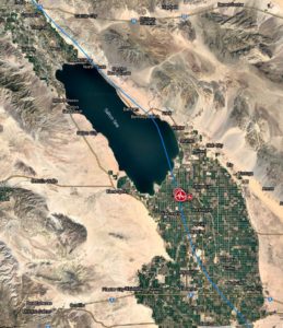
An intense earthquake swarm started near Salton Sea, California on September 30, 2020, with 421 earthquakes detected by 07:00 UTC on October 1.

  • The swarm is centered just southeast of Salton Sea, near Westmorland in Imperial Valley, in an area with a history of intense swarms. The most notable earthquakes in the region include M5.8 in 1981 and M5.4 in 2012.
  • During this earthquake swarm, the probability of larger earthquakes in this region is significantly greater than usual, the USGS said.
  • The swarm is taking place in Brawley Seismic Zone, a network of small faults that connect the San Andreas and Imperial faults.

The USGS registered a total of 440 earthquakes from 10:06 UTC on September 30 to 07:33 UTC on October 1, 2020, with the largest M4.9 at 00:31 UTC on October 1, followed by M4.5, M4.4, M4.2, and two M4.1.

“This earthquake [M4.9] and the associated swarm are located in an area of diffuse seismic activity between the San Andreas fault in the north and the Imperial fault to the south,” USGS seismologists said in a statement.

“This area has also seen swarms in the past – notably the 1981 Westmorland swarm, which included a M5.8 earthquake, and the 2012 Brawley swarm, which included a M5.4 earthquake. Past swarms in this region have remained active for 1 to 20 days, with an average duration of about a week. The current swarm is occurring about 40 kilometers (25 miles) to the south of the swarm that occurred near Bombay Beach in August 2020.”

According to the USGS, there is approximately a 3 in 10 000 chance of a magnitude 7+ earthquake in the vicinity of this swarm in a typical week.

“[This is] one of the largest swarms we have had in the Imperial Valley,” seismologist Dr. Lucy Jones said.

https://watchers.news

WSU researchers: Asian giant hornet has potential to spread down West Coast

KIRO 7 – September 23, 2020

PULLMAN, Wash. — Researchers at Washington State University say they have predicted how and where the Asian giant hornet – also dubbed the “murder hornet” — could spread and find ideal places to live in the US and across the world.

The team found that if the hornet gets a foothold in Washington state, it could spread down much of the West Coast.

The hornet could also find habitat throughout the eastern seaboard and parts of Africa, Australia, Europe and South America if humans accidentally transport it.

Researchers say the predictions emphasize how important it is to stop the large hornets in Washington before they spread.

Scientists from the state Department of Agriculture and WSU entomologists examined hundreds of records from the hornet’s native range in Japan, South Korea and Taiwan, then used a set of ecological models and climate information to predict where it could likely live across six continents.

“We’re making an educated guess on how fast and far these insects can move, their rate of success in establishing a nest, and offering different scenarios, from least bad to worst. No one has done this before for this species,” said WSU entomologist Javier Illan.

Experts say the Asian giant hornet is a significant threat to Western honey bees. In late summer and fall, hornet colonies attack beehives, destroying entire colonies.

The hornets are most likely to thrive in places with warm summers, mild winters and a lot of rain. High heat will kill them, so their best habitats are in areas with a high temperature of 102 degrees.

Giant hornets could live along much of the US west and east coasts, adjacent parts of Canada, much of Europe, northwestern and southeastern South America, central Africa, eastern Australia and most parts of New Zealand, WSU said in a news release.

https://www.kiro7.com

Sally leaves trail of destruction across Gulf Coast

Gianrigo Marletta, with Leila Macor – September 17, 2020

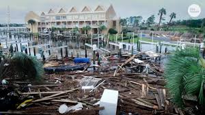
Shellshocked residents were cleaning up on Thursday after Hurricane Sally left a trail of destruction in US coastal towns stretching from Alabama to the top of the Florida panhandle.

Sally, which made landfall Wednesday as a Category 2 hurricane, turned streets into rivers, toppled trees and downed power lines.

“Our house had windows blow out,” Matt Wilson of Orange Beach, Alabama, one of the worst hit towns, told WPMI TV. “The whole house was shaking like a boat on the water.

“It was scary, man, it really was.”

Lieutenant Trent Johnson of the Orange Beach Police Department told AFP there had been one death in the city.

More than 400,000 homes and businesses in Alabama and Florida were still without power on Thursday, according to the tracking site poweroutage.us.

Some of the worst reported flooding occurred in the city of Pensacola, Florida, which has a population of around 52,000.

Downtown streets resembled lakes at the height of the storm with cars submerged to the tops of their wheels and ferocious winds whipping up whitecaps.

Florida Governor Ron DeSantis was to visit Pensacola on Thursday to survey the damage, which included a missing section of a major new bridge across Pensacola Bay.

A 7:00 pm to 6:00 am curfew was imposed in Pensacola and surrounding counties.

Wilson, the Orange Beach resident, said his house had suffered severe damage and his family fled their home at the height of the storm.

“Everything on the ground floor is gone,” he told WPMI. “We ended up leaving the house during the eye of the storm… and waded through about five foot of water to our neighbor’s house arm in arm.”

https://www.spacedaily.com

10 Percent of Oregon Told to Evacuate as US West Wildfires Kill 24

Newsmax – September 11, 2020

Around half a million people in Oregon, or 10% of the state’s population, were ordered to evacuate on Friday and residents of its largest city, Portland, were told to be ready to go as extreme wind-driven wildfires scorched U.S. West Coast states, causing at least 24 deaths.

About 100 wildfires have burned an area nearly as large as the state of New Jersey across the U.S. West, creating smoke that gave California, Oregon and Washington state the worst air quality levels in the world.

Oregon bore the brunt of the destruction, with search teams still unable to enter areas where fires burned through multiple small communities in the Cascade mountains.

Molalla, a community about 25 miles (40 km) south of downtown Portland, was an ash-covered ghost town after its more than 9,000 residents were told to evacuate, only 30 refusing to leave, the city’s fire department said.

The logging town was on the front line of a vast evacuation zone stretching north to within three miles (4.8 km) of downtown Portland, with Clackamas County police setting a 10 p.m. PT (0500 on Saturday GMT) curfew to deter “possible increased criminal activity.”

About 10 percent of the state’s population faced red “GO!” warnings to leave homes immediately, while hundreds of thousands more were under yellow “BE SET” warnings, to leave at a moment’s notice, or green “BE READY” alerts.

Towns southeast of Portland were at the mercy of wind direction and strength after two of Oregon’s largest wildfires merged into one.

https://www.newsmax.com

Return Of The Dust Bowl? The “Megadrought” In The Southwest Is Really Starting To Escalate

– August 28, 2020

Much of the southwestern portion of the United States has been gripped by a drought that never seems to end, and there is a tremendous amount of concern that patterns that we witnessed back during the Dust Bowl days of the 1930s may be starting to repeat.  In a previous article, I discussed the extreme heat that we have been seeing in the region lately.  Phoenix has never had more days in a year when the high temperature has hit at least 115 degrees, and other southwestern cities have been smashing records as well.  At the same time, precipitation levels have been very low, and the combination of these two factors is starting to cause some major problems.

A couple of weeks ago, NASA posted an article on their official website about the horrible drought conditions that we are now witnessing…

As the United States moves into the last weeks of climatological summer, one-third of the country is experiencing at least a moderate level of drought. Much of the West is approaching severe drought, and New England has been unusually dry and hot. An estimated 53 million people are living in drought-affected areas.

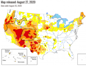
Since NASA posted that article, things have gotten even worse.  If you go to the U.S. Drought Monitor website, you will instantly see why so many experts are deeply concerned.  The latest map shows that nearly the entire southwestern quadrant of the country is now gripped by either “severe” or “extreme” drought.  Needless to say, this is not good news at all for farmers and ranchers in the region.

Colorado is one of the states that is being hit the hardest.  At this point, more than 93 percent of the entire state is experiencing very serious drought conditions

According to United States Drought Monitor, drought conditions have gotten significantly worse in Colorado in recent days and weeks.

Last week, approximately 72 percent of Colorado was experiencing “severe” drought conditions or worse. This has now jumped to just over 93 percent.

http://endoftheamericandream.com

Hurricane Laura Leaves Trail of CAT-4 Destruction, Looks like 100 Tornadoes struck

Ricky Scaparo – August 27, 2020

(ETH) – Hurricane Laura is being called one of the strongest hurricanes ever to strike the US is and is moving North and East after pounding the Gulf Coast. Although Laura has reportedly been downgraded to a tropical storm, it has left hurricane damage that stretches for hundreds of miles.

The report from CBN is indicating that streets are flooded, power lines toppled, homes destroyed, and trucks have been tossed like toys. At least three people have been reported to have been killed by falling trees in Louisiana.

Brett Geymann in Moss Bluff, just north of Lake Charles, testified that his family’s OK but “there’s destruction all around”. “It looks like 1,000 tornadoes” came through, he said, with some houses “totally gone.” The report states that destruction extended West across the state line from Louisiana into Texas.

The devastating storm has also produced a large chemical fire that has sent a potentially dangerous cloud over Lake Charles, Louisiana, and has residents being advised to shelter in place. Over half a million people in Texas and Louisiana were forced to evacuate as the storm rapidly strengthened into a catastrophic Category 4 storm in the Gulf of Mexico.

https://www.christianpost.com

Sinabung volcano erupts again just hours after twin M6.8 and M6.9 quakes hit off the coast of Sumatra, Indonesia – M6.6 earthquake the day before in Malaysia

Strange Sounds – August 20, 2020

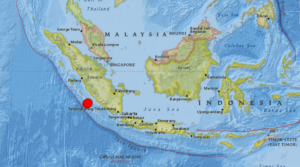
A pair of powerful earthquakes has rocked the Indonesian coast on August 19, 2020.

The M6.8 and M6.9 quakes shook the island of Sumatra maybe triggering the latest eruption of Sinabung volcano just hours later.

The two quakes struck off Sumatra’s western coast on Wednesday morning, with an estimated depth of 22km (13 miles) and 26km (16 miles) respectively. The first tremor impacted an area some 144km (89 miles) away from Bengkulu, while the second came closer to the city at 130km (80 miles).

There are no reports of injuries as of yet, however local media said the quakes shook the homes of island residents “as if a truck had passed” and did “minor damage,” particularly to buildings with “poor construction.”

Though the jolts were strong and shallow, Indonesia’s Meteorology, Climatology, and Geophysical Agency (BMKG) reported that there was “no tsunami potential” in the quakes’ aftermath.

In addition to being prone to quakes, Indonesia also features some of the most active volcanoes in the Ring – including Krakatoa, whose infamous 1883 eruption became one of the most deadly volcanic blasts in recorded history.

But a few hours after the two big jolts, the Sinabung volcano started erupting again – and not the Krakatoa.

A day before, a M6.6 earthquake hit the Philippines on Tuesday, killing at least one person and damaging roads and buildings.

It was the strongest earthquake in eight months in the Philippines, which, like Indonesia, lies on the “Ring of Fire,” a seismically active belt of volcanoes circling the Pacific Ocean.

https://strangesounds.org

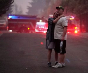
Thousands flee as fast-moving wildfires spread in California

Jocelyne Zablit – August 20, 2020

Thousands of people fled their homes in northern California on Wednesday as hundreds of fast-moving wildfires spread across the region, burning houses and leading to the death of a helicopter pilot.

In Vacaville — a city of about 100,000 people located between the state capital Sacramento and San Francisco — residents were urged to evacuate during the night as the wind-whipped flames swallowed dozens of homes.

Many were awakened by neighbors or firefighters desperately banging on their doors, and rushed out dressed only in their pajamas. Several suffered burns as they ran for their lives.

Evacuation orders or warnings were also issued in other counties — including the wine regions of Sonoma and Napa — where fires sparked by lightning are raging unchecked amid a sweltering heat wave.

Cal Fire officials said the series of fires in that region, dubbed the LNU Lightning Complex, had destroyed 50 homes, burned through nearly 50,000 acres and were zero percent contained by early Wednesday evening.

They added that a helicopter pilot taking part in the firefighting efforts in Fresno County, southeast of San Francisco, had died in a crash as he was attempting to drop water.

In Santa Cruz and San Mateo counties a series of fires called the CZU Lightning Complex forced the shutdown of portions of the iconic coastal Highway 1 as flames came close to the road.

Officials said the region’s rugged terrain and dry vegetation were making it difficult to combat the blaze.

Governor Gavin Newsom, who has declared a state of emergency to facilitate the release of emergency funds, said the wildfires had been caused by thousands of lightning strikes in recent days in the Bay Area.

https://www.terradaily.com

Millions Of Acres Of Crops In The Central U.S. Have Been Destroyed By A Series Of Historic Natural Disasters

– August 12, 2020

While the mainstream media focuses on the upcoming election, COVID-19 and the endless protests going on in our major cities, another great tragedy is unfolding all across the middle of the country.  A nightmarish drought, horrific flooding along the Mississippi River and a giant “derecho” that just hit the farm belt have combined to make this one of the toughest years for farmers ever.  And this comes at a particularly bad time, because the stress that the COVID-19 pandemic has put on food distribution systems has already created periodic shortages of certain items around the nation.  We definitely could have used an uneventful growing season this year, and unfortunately we didn’t get it.

On Monday, an absolutely massive “derecho” roared through the Midwest.  According to USA Today, the storm had winds of up to 112 miles per hour…

The storm had winds of up to 112 mph near Cedar Rapids, Iowa – as powerful as an inland hurricane – as it tore from eastern Nebraska across Iowa and parts of Wisconsin, Indiana and Illinois, including Chicago and its suburbs.

Most hurricanes don’t have winds that high once they finally reach shore, and I have personally never experienced wind speeds of such magnitude.

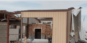
Needless to say, this very unusual storm caused immense devastation.  According to Iowa Governor Kim Reynolds, approximately 10 million acres of crops were destroyed in Iowa alone…

Early estimates say the derecho flattened at least one-third of Iowa’s crops – about 10 million acres, according to Iowa Gov. Kim Reynolds. In addition, tens of millions of bushels of grain that were stored at co-ops and on farms were damaged or destroyed as bins blew away.

And it rocked Marshalltown, Iowa, where an EF-3 tornado destroyed the town’s business district just two years ago. With winds of 99 mph, Monday’s storm damaged some businesses that had recently recovered, even damaging the scaffolding being used to repair the historic courthouse dome.

I can’t remember a storm ever causing this much damage in the middle of the summer.

If about 10 million acres were flattened just in Iowa, how many more acres did this storm destroy in Nebraska, Wisconsin, Indiana and Illinois?

Sadly, this one storm is going to completely financially ruin some farmers.  For example, Iowa farmer Tim Bardole is facing losses that could potentially exceed one million dollars.

http://theeconomiccollapseblog.com