Major M7.3 earthquake triggers hazardous tsunami warning, cracks roads and destroys buildings in Indonesia – People run out of homes screaming out loud

Strange Sounds – December 14, 2021

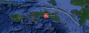
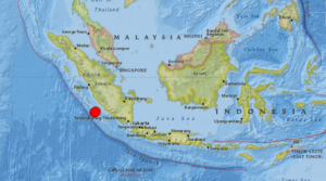
An undersea earthquake of magnitude 7.3 has struck off the coast of Indonesia’s Flores Island, prompting the country’s monitoring agency to issue a tsunami warning which was later called off.

The US Geological Survey said that the quake occurred at a depth of 18.5km under the sea and was located 112km north of the second-largest island town in East Nusa Tenggara province.

The casualties from the undersea earthquake are not immediately clear. However, authorities said several buildings and public properties suffered damage as photos showed roads cracked open by the temblor.

Another photo by local media showed a wall demolished due to the impact of the quake and bricks strewn on the road in South Sulawesi.Almost two hours after the quake, Indonesia’s Meteorology, Climatology, and Geophysical Agency agency called off the tsunami warning but asked locals in East Nusa Tenggara and South Sulawesi to remain vigilant.

Hazardous tsunami waves are possible for coasts located within 1,000km of the epicentre, the US-based Pacific Tsunami Warning Centre had said in the initial warning.

Preliminary visuals from the island nation showed people rushing out of their homes, away from the sea and running towards safe areas.

Everyone ran out into the street,” according to a resident of Maumere town on Flores island.

https://strangesounds.org

Shallow M6.1 earthquake hits Seram Island, Indonesia – tsunami warning issued

A shallow earthquake registered by the Indonesian BMKG as M6.1 hit Seram Island, Moluccas, Indonesia at 04:43 UTC (11.43 LT) on June 16, 2021. The agency is reporting a depth of 10 km (6.2 miles). EMSC and USGS are reporting M5.8 at a depth of 10.6 km (6.6 miles).

The epicenter was located 70.6 km (43.9 miles) ESE of Amahai (population 47 653) and 147 km (91.3 miles) E of Ambon (population 355 596), Maluku, Indonesia.

There are 300 000 people living within 100 km (62 miles).

9 000 people are estimated to have felt moderate shaking and 278 000 light, according to the USGS.

The Indonesian Agency for Meteorology, Climatology and Geophysics (BMKG) warned of possible aftershocks and tsunami potential, especially to Seram Island. “Please move away from beaches and move to higher ground,” BMKG said.

While the agency initially said there was no tsunami potential, it later said a tsunami wave could potentially be triggered by landslides.

“The results of tsunami modeling with a tectonic earthquake source showed that this earthquake has no tsunami potential, but based on observations of sea level… it showed the sea level rose as high as 0.5 m (1.6 feet),” BMKG said.

Residents along the coast of Tehoru panicked and ran up nearby hills when the sea started rising, but many have since returned home.

Local officials said some buildings sustained damage like cracked walls and windows, but there were no reports of injuries or casualties.

https://watchers.news

Ring of Fire earthquake ALERT: TEN huge quakes hit Indonesia in 4 hours – tsunami warning

James Bickerton – February 10, 2021

A SERIES of powerful earthquakes struck off Indonesia and New Caledonia – sparking tsunami fears.

An earthquake of magnitude 7.7 struck southeast of Loyalty Islands on Wednesday, the European Mediterranean Seismological Centre (EMSC) said. The quake’s epicentre was 401 km east of Tadine, New Caledonia, and was at a depth of 2 km, EMSC said. Ten earthquakes and aftershocks hit the region in a short space of time – ranging between a magnitude of 5.0-6.2 – with the first quake at 12.24.21 (UTC) and the final at 14.59.37 (UTC).

In response, a tsunami warning was issued with waves of between 0.3 and one-meter feared for Fiji, Vanuatu and New Zealand.

A lesser warning for a tsunami of up to 0.3 meters was issued for Australia, Papua New Guinea and American Samoa.

Separately an earthquake of magnitude 6.2 struck southwest of Sumatra, Indonesia, on Wednesday, the European Mediterranean Seismological Centre (EMSC) said.

The quake was at a depth of 30 km (18.64 miles), EMSC said.

It struck around 217 kilometres to the south-west of Bengkulu, a city of 328,000 people, at 19:52 local time (12:52 GMT).

https://www.express.co.uk

Powerful Indonesia quake kills at least 37, topples buildings

Haeril HALIM, Agnes ANYA – January 25, 2021

A powerful earthquake rocked Indonesia’s Sulawesi island Friday, killing at least 37 people, levelling a hospital and severely damaging other buildings, authorities said, as they warned there were people still trapped beneath rubble.

Hundreds were also injured when the 6.2-magnitude quake struck in the early hours, triggering panic among the terrified residents of the island, which was hit by a huge quake and tsunami two and a half years ago that killed thousands.

So far, 29 bodies have been hauled from beneath crumpled buildings in Mamuju, a city of about 110,000 in West Sulawesi province, while another eight were killed south of the area after the quake struck.

“We don’t know how many more are missing,” said Arianto from the rescue agency in Mamuju, who like many Indonesians goes by one name.

“There are still people trapped beneath the rubble.”

Rescuers were searching for more than a dozen patients and staff trapped under a levelled Mamuju hospital.

“The hospital is flattened — it collapsed,” Arianto said.

Earlier Friday, rescuers said they were also trying to reach a family of eight who were under their destroyed home.

At least one hotel had partially collapsed, while the regional governor’s office also suffered extensive damage after the quake struck at 2:18 am local time Friday (1818 GMT Thursday).

A Mamuju resident said damage across the city was severe.

https://www.spacedaily.com

Sinabung volcano erupts again just hours after twin M6.8 and M6.9 quakes hit off the coast of Sumatra, Indonesia – M6.6 earthquake the day before in Malaysia

Strange Sounds – August 20, 2020

A pair of powerful earthquakes has rocked the Indonesian coast on August 19, 2020.

The M6.8 and M6.9 quakes shook the island of Sumatra maybe triggering the latest eruption of Sinabung volcano just hours later.

The two quakes struck off Sumatra’s western coast on Wednesday morning, with an estimated depth of 22km (13 miles) and 26km (16 miles) respectively. The first tremor impacted an area some 144km (89 miles) away from Bengkulu, while the second came closer to the city at 130km (80 miles).

There are no reports of injuries as of yet, however local media said the quakes shook the homes of island residents “as if a truck had passed” and did “minor damage,” particularly to buildings with “poor construction.”

Though the jolts were strong and shallow, Indonesia’s Meteorology, Climatology, and Geophysical Agency (BMKG) reported that there was “no tsunami potential” in the quakes’ aftermath.

In addition to being prone to quakes, Indonesia also features some of the most active volcanoes in the Ring – including Krakatoa, whose infamous 1883 eruption became one of the most deadly volcanic blasts in recorded history.

But a few hours after the two big jolts, the Sinabung volcano started erupting again – and not the Krakatoa.

A day before, a M6.6 earthquake hit the Philippines on Tuesday, killing at least one person and damaging roads and buildings.

It was the strongest earthquake in eight months in the Philippines, which, like Indonesia, lies on the “Ring of Fire,” a seismically active belt of volcanoes circling the Pacific Ocean.

https://strangesounds.org