Shallow M6.1 earthquake hits Seram Island, Indonesia – tsunami warning issued

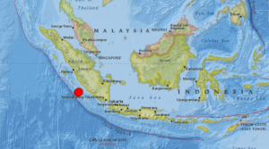
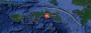
A shallow earthquake registered by the Indonesian BMKG as M6.1 hit Seram Island, Moluccas, Indonesia at 04:43 UTC (11.43 LT) on June 16, 2021. The agency is reporting a depth of 10 km (6.2 miles). EMSC and USGS are reporting M5.8 at a depth of 10.6 km (6.6 miles).

The epicenter was located 70.6 km (43.9 miles) ESE of Amahai (population 47 653) and 147 km (91.3 miles) E of Ambon (population 355 596), Maluku, Indonesia.

There are 300 000 people living within 100 km (62 miles).

9 000 people are estimated to have felt moderate shaking and 278 000 light, according to the USGS.

The Indonesian Agency for Meteorology, Climatology and Geophysics (BMKG) warned of possible aftershocks and tsunami potential, especially to Seram Island. “Please move away from beaches and move to higher ground,” BMKG said.

While the agency initially said there was no tsunami potential, it later said a tsunami wave could potentially be triggered by landslides.

“The results of tsunami modeling with a tectonic earthquake source showed that this earthquake has no tsunami potential, but based on observations of sea level… it showed the sea level rose as high as 0.5 m (1.6 feet),” BMKG said.

Residents along the coast of Tehoru panicked and ran up nearby hills when the sea started rising, but many have since returned home.

Local officials said some buildings sustained damage like cracked walls and windows, but there were no reports of injuries or casualties.

https://watchers.news

Sinabung volcano erupts again just hours after twin M6.8 and M6.9 quakes hit off the coast of Sumatra, Indonesia – M6.6 earthquake the day before in Malaysia

Strange Sounds – August 20, 2020

A pair of powerful earthquakes has rocked the Indonesian coast on August 19, 2020.

The M6.8 and M6.9 quakes shook the island of Sumatra maybe triggering the latest eruption of Sinabung volcano just hours later.

The two quakes struck off Sumatra’s western coast on Wednesday morning, with an estimated depth of 22km (13 miles) and 26km (16 miles) respectively. The first tremor impacted an area some 144km (89 miles) away from Bengkulu, while the second came closer to the city at 130km (80 miles).

There are no reports of injuries as of yet, however local media said the quakes shook the homes of island residents “as if a truck had passed” and did “minor damage,” particularly to buildings with “poor construction.”

Though the jolts were strong and shallow, Indonesia’s Meteorology, Climatology, and Geophysical Agency (BMKG) reported that there was “no tsunami potential” in the quakes’ aftermath.

In addition to being prone to quakes, Indonesia also features some of the most active volcanoes in the Ring – including Krakatoa, whose infamous 1883 eruption became one of the most deadly volcanic blasts in recorded history.

But a few hours after the two big jolts, the Sinabung volcano started erupting again – and not the Krakatoa.

A day before, a M6.6 earthquake hit the Philippines on Tuesday, killing at least one person and damaging roads and buildings.

It was the strongest earthquake in eight months in the Philippines, which, like Indonesia, lies on the “Ring of Fire,” a seismically active belt of volcanoes circling the Pacific Ocean.

https://strangesounds.org