Powerful M6.8 earthquake kills one in Michoacan, Mexico just three days after a M7.6 shook the same area, killing two

Strange Sounds – September 22, 2022

A powerful earthquake with a preliminary magnitude of 6.8 struck Mexico early Thursday, causing buildings to sway and leaving at least one person dead in the nation’s capital.

The earthquake struck shortly after 1 a.m., just three days after a 7.6-magnitude earthquake shook western and central Mexico, killing two.

The U.S. Geological Survey said Thursday’s earthquake, like Monday’s, was centered in the western state of Michoacan near the Pacific coast.

The epicenter was about 29 miles (46 kilometers) south-southwest of Aguililla, Michoacan, at a depth of about 15 miles (24.1 kilometers).

Michoacan’s state government said the quake was felt throughout the state.

It reported damage to a building in the city of Uruapan and some landslides on the highway that connects Michoacan and Guerrero with the coast.

President Andrés Manuel López Obrador said via Twitter that it was an aftershock from Monday’s quake and was also felt in the states of Colima, Jalisco and Guerrero.

Mexico City Mayor Claudia Sheinbaum said via Twitter that one woman died in a central neighborhood when she fell down the stairs of her home.

The earthquake rattled an already jittery country.

Monday’s more powerful quake was the third major earthquake to strike on Sept. 19 — in 1985, 2017 and now 2022.

https://strangesounds.org

South Carolina rocked by two of the largest earthquakes in years, Quake swarm continues, residents on edge

ETH – June 29, 2022

South Carolina was rocked by several earthquakes Wednesday, including the two strongest yet in a “swarm” of earthquakes that have rattled the state this year according to USA Today. 

Two quakes that are unusually strong for the region struck central South Carolina on Wednesday — a magnitude 3.5 and a magnitude 3.6, according to data from the United States Geological Survey. Over the weekend, a magnitude 3.4 earthquake also shook the state.

The quakes are the most powerful to hit the state in years, and at least one of Wednesday’s tremblers could be felt near Charlotte, North Carolina, according to reports published by the United States Geological Survey.

In a video shared by the state’s Emergency Management Division, geologist Wendy Bohon said more than 30 quakes have hit the state this year, a part of an “earthquake swarm.” Such swarms are familiar occurrences in more earthquake-prone areas, but less common in the South.

The South Carolina swarm has been going on for over half a year and included seven quakes above a magnitude 3, according to seismologist Lucy Jones. “Swarms happen in all seismic regions and the earthquakes continue until they stop,” Jones tweeted.

“That may not seem helpful, but knowing this is normal can help.” The latest quakes occurred near Elgin, South Carolina, according to data from the United States Geological Survey. The town is located about 20 miles northeast of Columbia, the state’s capital.

https://endtimeheadlines.org

Huge 7.3 magnitude earthquake strikes near remote Australian island

Ricky Scaparo – May 19, 2022

A 7.3 magnitude earthquake has been recorded near a remote Australian island. The Bureau of Meteorology reported the quake near Macquarie Island in the southwest Pacific Ocean at 8.49 pm on Thursday.

According to the Daily Mail, The earthquake was at a depth of 29.3km. BOM and the Australian territory located south of New Zealand on was briefly on tsunami warning but this was lifted by 10pm.

The quake was also recorded by the US Geological Survey. Located 1,600km southeast of Tasmania, Macquarie Island is home is to the Australian Antarctic Division station, which is occupied all year round. It has been listed as a UNESCO World Heritage Site since 1997 and is a refuge for large colonies of penguins and seals.

The island is particularly active in terms of seismic activity, sitting on the boundary between the Australian Plate and the Pacific plate. The Joint Australian Tsunami Warning Centre initially put Australia on tsunami alert. According to the International Tsunami Information Centre, a “tsunami warning is issued when a tsunami with the potential to generate widespread inundation is imminent, expected, or occurring.

Warnings alert the public that dangerous coastal flooding accompanied by powerful currents is possible and may continue for several hours after initial arrival”. They later released an update confirming there was no risk of a tsunami.

https://endtimeheadlines.org

Strong and shallow M6.7 earthquake hits near the coast of Nicaragua

The Watchers – April 21, 2022

A strong and shallow earthquake registered by the USGS as M6.7 hit near the coast of Panama at 07:24 UTC on April 21, 2022. The agency is reporting a depth of 25.3 km (15.7 miles). EMSC is reporting M6.7 at a depth of 40 km (24.8 miles).

The epicenter was located about 58.2 km (36.2 miles) WSW of Masachapa (population 5 000), 68.7 km (42.7 miles) WSW of San Rafael del Sur (population 29 836), and 88.8 km (55.2 miles) WSW El Crucero (population 16 469), Managua, Nicaragua.

There are 910 000 people living within 100 km (62 miles).

1 000 people are estimated to have felt strong shaking and 807 000 moderate.

Based on all available data, there is no tsunami threat from this earthquake, PTWC said.

The USGS issued a Green alert for shaking-related fatalities and economic losses. There is a low likelihood of casualties and damage.

Overall, the population in this region resides in structures that are highly vulnerable to earthquake shaking, though some resistant structures exist. The predominant vulnerable building types are mud wall and adobe block construction.

Recent earthquakes in this area have caused secondary hazards such as landslides that might have contributed to losses.

https://watchers.news

Earthquake rattles unusual location in Illinois, Precursor to New Madrid activity?

Ricky Scaparo – April 14, 2022

(OPINION) – Since we live near the New Madrid Fault, it’s normal to have earthquakes in our region. However, there was an earthquake that was felt by many that just happened in a weird part of Illinois.

According to the USGS, there was a 2.6 earthquake, but it wasn’t in the normal area near New Madrid. It was in the southeastern part of the state. This relatively tiny shaker occurred at 1:40 am early Wednesday morning, but was felt by 18 as of this writing.

Along with the non-typical location, it’s odd to me that a quake of only 2.6 magnitude would actually be felt in the middle of the night. A quake that small would be hard to detect even in the middle of the day if you were wide awake.

It’s close enough to what the USGS considers the New Madrid Fault Zone that it’s likely related to activity there. However, it’s just strange enough to pass along in case it’s the forerunner of something more major.

https://endtimeheadlines.org

Back to back powerful earthquakes strike southeast of the Loyalty Islands, New Caledonia

Ricky Scaparo – March 31, 2022

A very strong and shallow earthquake registered by the USGS as M7.0 struck southeast of the Loyalty Islands, New Caledonia according to a report from the Watchers, at 05:44 UTC on March 31, 2022. The agency is reporting a depth of 10 km (6.2 miles).

EMSC is reporting the same magnitude and depth. The quake was preceded by M6.9 (USGS) / M6.7 (EMSC) at 20:56 UTC on March 30, and a series of moderate to strong aftershocks. The epicenter was located about 280 km (174 miles) ESE of Tadine, New Caledonia, and 368 km (229 miles) SSE of Isangel, Vanuatu.

There are no people living within 100 km (62 miles). Based on all available data, hazardous tsunami waves are forecast for some coasts, NWS PTWC said. Tsunami waves are forecast to be less than 0.3 m (0.98 feet) above tide level for the coasts of Fiji, New Caledonia, and Vanuatu.

Actual amplitudes at the coast may vary from forecast amplitudes due to uncertainties in the forecast and local features. In particular maximum tsunami amplitudes on atolls and at locations with fringing or barrier reefs will likely be much smaller than the forecast indicates.

https://endtimeheadlines.org

Major M7.4 earthquake hits near the coast of Fukushima Prefecture, Japan

– March 16, 2022

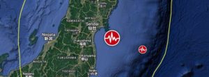
A major earthquake registered by the Japan Meteorological Agency (JMA) as M7.4 hit near the coast of Fukushima Prefecture at 14:36 UTC (23:36 JTC) on March 16, 2022. The agency is reporting a depth of 60 km (37 miles). USGS is reporting M7.3 at a depth of 33 km (20 miles), EMSC M7.2 at a depth of 80 km (49 miles). The quake was preceded by M6.4 at 14:34 UTC at a depth of 56 km (35 miles).

The epicenter was located about 66 km (41 miles) ENE of Namie (population 21 866), Fukushima and 96 km (59 miles) SE of Sendai (population 1 063 103), Miyagi, Japan.

There are about 1.8 million people living within 100 km (62 miles).

JMA has issued a Tsunami Advisory for the Fukushima and Miyagi prefectures, with waves up to 1 m (3.3 feet) expected. A Tsunami Forecast is in effect for most of Japan’s eastern coastal areas.

2 046 000 people are estimated to have felt very strong shaking, 3 200 000 strong and 7 379 000 moderate.

The USGS issued a Green alert for shaking-related fatalities. There is a low likelihood of casualties.

A Yellow alert was issued for economic losses. Some damage is possible and the impact should be relatively localized. Estimated economic losses are less than 1% of GDP of Japan. Past events with this alert level have required a local or regional level response.

Overall, the population in this region resides in structures that are resistant to earthquake shaking, though vulnerable structures exist. The predominant vulnerable building types are heavy wood frame and reinforced/confined masonry construction.

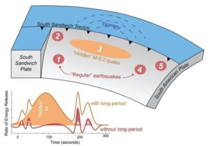
Recent earthquakes in this area have caused secondary hazards such as tsunamis, landslides and fires that might have contributed to losses.

Updates

The earthquake has left 4 people dead and more than 160 injured. (Mainichi)

The quake caused power outages in northeastern and eastern Japan, affecting a total of more than 2.2 million households, including some 700 000 in Tokyo. Power was later restored to most of the affected citizens.

The country’s nuclear regulator said data show no abnormalities with reactors and facilities at the Fukushima Daiichi nuclear power plant, although the cooling system for the spent fuel pools at the No. 2 and No. 5 reactors temporarily stopped. Cooling systems for spent fuel pools at the Fukushima Daini nuclear power plant and the Onagawa nuclear plant in Miyagi were also affected before recovering.

A Tohoku Shinkansen bullet train derailed between Fukushima Station and Shiroishizao Station, but all 78 passengers and crew members aboard were unharmed, according to East Japan Railway Co.

Relatively small tsunami waves were observed at Ishinomaki port in Miyagi and other locations.

https://watchers.news

Hidden M8.2 earthquake triggers mysterious 2021 global tsunami

Strange Sounds – February 9, 2022

Scientists have uncovered the source of a mysterious 2021 tsunami that sent waves around the globe. A magnitude 8.2 earthquake was “hidden” within a magnitude 7.5 earthquake in 2021, sending a mysterious tsunami around the world.

In August 2021, a magnitude 7.5 earthquake hit near the South Sandwich Islands, creating a tsunami that rippled around the globe. The epicenter was 47 kilometers below the Earth’s surface — too deep to initiate a tsunami — and the rupture was nearly 400 kilometers long, which should have generated a much larger earthquake.

Seismologists were puzzled and sought to understand what really happened that day in the remote South Atlantic.

A new study revealed the quake wasn’t a single event, but five, a series of sub-quakes spread out over several minutes. The third sub-quake was a shallower, slower magnitude 8.2 quake that hit just 15 kilometers below the surface. That unusual, “hidden” earthquake was likely the trigger of the worldwide tsunami.

The study was published in the AGU journal Geophysical Research Letters, which publishes short-format, high-impact papers with implications that span the Earth and space sciences.

Because the South Sandwich Islands earthquake was complex, with multiple sub-quakes, its seismic signal was difficult to interpret, according to lead study author Zhe Jia, a seismologist at the California Institute of Technology. The magnitude 8.2 quake was hidden within the tangle of seismic waves, which interfered with each other over the course of the event. The hidden quake’s signal wasn’t clear until Jia filtered the waves using a much longer period, up to 500 seconds. Only then did the 200-second-long quake, which Jia said accounted for over 70% of the energy released during the earthquake, become clear.

“The third event is special because it was huge, and it was silent,” Jia said. “In the data we normally look at [for earthquake monitoring], it was almost invisible.”

Predicting hazards for complex earthquakes can be difficult, as the South Sandwich Islands quake demonstrates. The USGS initially reported the magnitude 7.5 quake and only added the 8.2 event the following day, as the surprise tsunami lapped on shores up to 10,000 kilometers away from its point of origin.

“We need to rethink our way to mitigate earthquake-tsunami hazards. To do that, we need to rapidly and accurately characterize the true size of big earthquakes, as well as their physical processes,” Jia said.

https://strangesounds.org

Powerful M7.5 earthquake hits northern Peru

– November 28, 2021

A major earthquake registered by the USGS as M7.5 hit a very sparsely populated region of northern Peru at 10:52 UTC on November 28, 2021. The agency is reporting a depth of 112.5 km (69.9 miles). EMSC is reporting M7.5 at a depth of 110 km (68.3 miles).

The epicenter was located 43 km (27 miles) NNW of Barranca (population 5 779), and 173 km (107 miles) N of Moyobamba (population 44 276), Peru.

27 000 people are estimated to have felt severe shaking, 127 000 very strong, 1 090 000 strong, and 4 343 000 moderate.

The USGS issued a Yellow alert for shaking-related fatalities and economic losses. Some casualties and damage are possible and the impact should be relatively localized. Past yellow alerts have required a local or regional level response.

Estimated economic losses are less than 1% of GDP of Peru.

Overall, the population in this region resides in structures that are highly vulnerable to earthquake shaking, though some resistant structures exist. The predominant vulnerable building types are mud wall and reinforced/confined masonry construction.

USGS estimated limited number / and (or) spatial extent of landslides triggered by this earthquake. The number of people living near areas that could have produced landslides in this earthquake is low, but landslide damage or fatalities are still possible in highly susceptible areas.

Liquefaction triggered by this earthquake is estimated to be extensive in severity and (or) spatial extent and the number of people living near areas that could have produced liquefaction in this earthquake is significant.

https://watchers.news

WATCH: Rocks tumble down Sierra Nevada mountains after 6.0 quake & dozens of aftershocks rattle northern California

RT – July 9, 2021

A powerful 6.0 magnitude earthquake and dozens of aftershocks have struck the California-Nevada border area, triggering a rockslide in the Sierra Nevada mountain range and reports of shaking from San Francisco to Carson City.

The most powerful jolt, eventually upgraded by the US Geological Survey (USGS) to magnitud 6.0, happened at 3:49pm local time on Thursday, some 150 miles east of Sacramento. Within the next two hours, the area was rattled by over 50 aftershocks ranging between 2.5 and 4.6 on the Richter scale.

The quake was the “result of normal faulting in the shallow crust of the North America plate,” USGS said, noting however that there is a small chance this was a foreshock of a larger earthquake, according to CBS Sacramento.

The earthquake swarm occurred along the eastern edge of the Sierra Nevada, but witnesses reported shaking across much of Northern California, including the Sacramento region, and even as far away as San Francisco’s Bay Area and Carson City, Nevada.

The quake also triggered rockslides and a brief closure of Highway 395, where several cars were reportedly struck by rocks, though nobody was injured, according to the California Highway Patrol. Large boulders were seen scattered along the road in footage shared on social media.

Besides the rockslides, the state’s Office of Emergency Services said there were no immediate reports of major damage or injuries.

https://www.rt.com