Massive quake in Philippines has killed 5 and injured dozens, destroyed homes and structures

ETH – July 27, 2022

A strong earthquake set off landslides and damaged buildings in the northern Philippines on Wednesday, killing at least five people and injuring dozens. In the capital, hospital patients were evacuated and terrified people rushed outdoors.

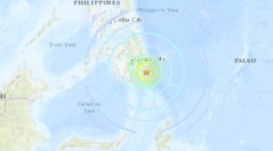
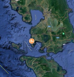
The 7-magnitude quake was centered in a mountainous area of Abra province, said Renato Solidum, the head of the Philippine Institute of Volcanology and Seismology, who described the midmorning shaking as a major earthquake.

“The ground shook like I was on a swing and the lights suddenly went out. We rushed out of the office, and I heard screams and some of my companions were in tears,” said Michael Brillantes, a safety officer of the Abra town of Lagangilang, near the epicenter. “It was the most powerful quake I’ve felt and I thought the ground would open up,” Brillantes told The Associated Press by cellphone.

At least five people died — mostly in collapsed structures. One villager died when hit by falling cement slabs in his house in Abra, where dozens of others were injured. In Benguet province, a worker was pinned to death after a small building that was under construction collapsed in the strawberry-growing mountain town of La Trinidad.

Hundreds of houses and buildings had cracked walls, including some that collapsed in Abra, where President Ferdinand Marcos Jr., who took office less than a month ago, planned to travel Thursday to meet victims and local officials.

Marcos Jr. told a news conference he was in his office at the riverside Malacanang presidential palace complex when the chandeliers began swaying and making clanking sounds. “It was very strong,” he said of the ground shaking.

In a chilling near-death experience, Filipino photojournalist Harley Palangchao and companions were traveling downhill in two vans in Mountain Province when they suddenly heard thunder-like thuds and saw an avalanche of boulders as big as cars raining down just ahead of them from a towering mountain.

https://endtimeheadlines.org

Tsunami THREAT for Philippines after M7.2 earthquake hits the coast of Mindanao

Strange Sounds – August 11, 2021

An earthquake of magnitude 7.1 has struck about 40 miles (63km) east of Pondaguitan in the Philippines.

The quake hit early morning on Thursday, August 12, 2021 around 1:46 am local time (5:46 GMT, August 11, 2021) at a depth of 65.6km (40.8 miles).

The major jolt has triggered tsunami threat within 186 miles of the epicenter, prompting a tsunami warning that was later cancelled.

Thailand’s earthquake monitoring center reported two aftershock quakes of 5.1 and 5.0 magnitude. More are expected.

Based on the preliminary seismic data, the quake should have been felt widely by almost everyone in the area of the epicenter.

The Philippine Institute of Volcanology and Seismology said that damage and aftershocks were expected.

https://strangesounds.org

Anticipating War With China, The U.S. Air Force Is Fanning Out Across The Pacific

David Axe – June 7, 2021

For years, the U.S. Air Force concentrated its warplanes at just two bases in the western Pacific: for fighters, Kadena Air Force Base in Japan’s Okinawa prefecture; and for bombers and big support planes, Guam’s Andersen Air Force Base.

Beijing eyed these mega-bases and devised a simple strategy for suppressing U.S. air power in the region. Build a couple thousand non-nuclear ballistic missiles and, in wartime, lob them at the bases until their runways, aprons, hangars, fuel tanks and warehouses are nothing but craters.

After years of build-up, the Chinese rocket force possesses around 1,300 ground-launched missiles with sufficient range to hit Kadena and Andersen from mainland China.

The USAF is keenly aware of the threat. It has its own plan for dodging the missile barrages. The idea is to spread out hundreds of warplanes across potentially dozens of smaller bases—thus diluting the striking power of China’s rocket force.

The Air Force won’t say exactly which bases are part of its plan, but it’s possible to make educated guesses. American territories and small island countries offer the most dependable facilities. Arguably the most important bases—in the Philippines—are accessible only at the whim of that country’s mercurial president.

The emerging map of the USAF’s expanding base network also reveals where the service has potential airfield gaps, most glaringly in the Philippine Sea east of Taiwan. In that gap, the U.S. Navy’s Pacific Fleet might lend its sister service a helping hand—and deploy some of its 10 aircraft carriers and big-deck assault ships.

The Air Force maintains a master list of what Gen. Kenneth Wilsbach, the head of Pacific Air Forces, described as “every single piece of concrete” in the Pacific region.

https://www.forbes.com

Powerful M7.1 earthquake hits off the coast of Mindanao, Philippines

– January 21, 2021

A powerful earthquake registered by PHIVOLCS as M7.1 hit off the coast of Mindanao, Philippines at 12:23 UTC (20:23 LT) on January 21, 2021. The agency is reporting a depth of 116 km (72 miles). The USGS is reporting M7.0 at a depth of 96 km (60 miles), EMSC M7.1 at a depth of 114 km (71 miles).

The epicenter was located about 211 km (131 miles) SE of Pondaguitan and 312 km (194 miles) SE of Davao, Philippines.

There are about 100 000 people living within 100 km (62 miles).

6 000 people are estimated to have felt strong shaking and 173 000 moderate.

Based on the depth of the earthquake, a tsunami is not expected, NTWC said.

The USGS issued a green alert for shaking-related fatalities and economic losses. There is a low likelihood of casualties and damage.

Overall, the population in this region resides in structures that are a mix of vulnerable and earthquake-resistant construction. The predominant vulnerable building types are unknown/miscellaneous types and heavy wood frame construction.

Recent earthquakes in this area have caused secondary hazards such as tsunamis and landslides that might have contributed to losses.

https://watchers.news

Strong M6.3 earthquake hits Mindoro, Philippines

– December 25, 2020

A strong earthquake registered by PHIVOLCS as M6.3 hit Mindoro, Philippines at 23:43 UTC on December 24, 2020 (07:43 LT, December 25). The agency is reporting a depth of 109 km (67 miles). The USGS is reporting the same magnitude and depth; EMSC M6.3 at a depth of 33 km (20 miles).

The epicenter was located 1.8 km (1.1 miles) SSW of Calatagan (population 16 110), 17.7 km (11 miles) SW of Balayan (population 50 115), 24.1 km (15 miles) WSW of Calaca (population 37 443), 27.7 km (17.2 miles) S of Nasugbu (population 62 857), and 73 km (45 miles) SW of Calamba (population 316 612), Philippines.

There are about 20 200 000 people living within 100 km (62 miles).

12 000 people are estimated to have felt strong shaking, 3 775 000 moderate, and 40 465 000 light.

Phivolcs said aftershocks are expected.

The USGS issued a green alert for shaking-related fatalities and economic losses. There is a low likelihood of casualties and damage.

Overall, the population in this region resides in structures that are a mix of vulnerable and earthquake-resistant construction. The predominant vulnerable building types are unknown/miscellaneous types and heavy wood frame construction.

Recent earthquakes in this area have caused secondary hazards such as landslides and liquefaction that might have contributed to losses.

https://watchers.news

Sinabung volcano erupts again just hours after twin M6.8 and M6.9 quakes hit off the coast of Sumatra, Indonesia – M6.6 earthquake the day before in Malaysia

Strange Sounds – August 20, 2020

A pair of powerful earthquakes has rocked the Indonesian coast on August 19, 2020.

The M6.8 and M6.9 quakes shook the island of Sumatra maybe triggering the latest eruption of Sinabung volcano just hours later.

The two quakes struck off Sumatra’s western coast on Wednesday morning, with an estimated depth of 22km (13 miles) and 26km (16 miles) respectively. The first tremor impacted an area some 144km (89 miles) away from Bengkulu, while the second came closer to the city at 130km (80 miles).

There are no reports of injuries as of yet, however local media said the quakes shook the homes of island residents “as if a truck had passed” and did “minor damage,” particularly to buildings with “poor construction.”

Though the jolts were strong and shallow, Indonesia’s Meteorology, Climatology, and Geophysical Agency (BMKG) reported that there was “no tsunami potential” in the quakes’ aftermath.

In addition to being prone to quakes, Indonesia also features some of the most active volcanoes in the Ring – including Krakatoa, whose infamous 1883 eruption became one of the most deadly volcanic blasts in recorded history.

But a few hours after the two big jolts, the Sinabung volcano started erupting again – and not the Krakatoa.

A day before, a M6.6 earthquake hit the Philippines on Tuesday, killing at least one person and damaging roads and buildings.

It was the strongest earthquake in eight months in the Philippines, which, like Indonesia, lies on the “Ring of Fire,” a seismically active belt of volcanoes circling the Pacific Ocean.

https://strangesounds.org

Officials block villagers as quakes shake Philippine volcano

AARON FAVILA and JIM GOMEZ – January 16,2020

LEMERY, Philippines (AP) — A Philippine volcano that erupted last weekend belched smaller plumes of ash but shuddered frequently with earthquakes Thursday, prompting authorities to block access to nearby towns due to fears of a bigger eruption.

A crater lake and nearby river on the Taal volcano dried up in signs of its continued restiveness, and officials have warned people against speculating that the five-day eruption is waning.

“We have a seeming lull, but, again, as we emphasized earlier, there is something different happening beneath the volcano,” Ma. Antonio Bornas of the Philippine Institute of Volcanology and Seismology told reporters, citing continued tremors, steaming and other signs of magma movement.

Renato Solidum, who heads the institute, said it may take up to two weeks for experts to assess whether the volcano’s restiveness has eased. The Taal area has remained just a notch down from the highest level of a five-step alert system the institute uses to warn the public of a volcano’s danger.

Soldiers and police blocked villagers from going back to the island volcano and nearby towns to retrieve belongings, poultry and cattle.

Many houses and farms have been damaged by volcanic ash since the eruption started Sunday, though no deaths or major injuries have been reported after tens of thousands of people evacuated.

A 65-year-old woman died of a heart attack while being moved out of Taal town in Batangas province but officials said she had been ill and may have been stressed by the calamity. Batangas province lies more than 65 kilometers (40 miles) south of the capital, Manila.

Amid warnings of a possible imminent and more dangerous eruption, police cordoned off at least four towns near shores of a lake that surrounds the volcano. The move sparked arguments with villagers.

https://apnews.com