WATCH: Rocks tumble down Sierra Nevada mountains after 6.0 quake & dozens of aftershocks rattle northern California

RT – July 9, 2021

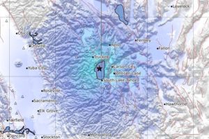
A powerful 6.0 magnitude earthquake and dozens of aftershocks have struck the California-Nevada border area, triggering a rockslide in the Sierra Nevada mountain range and reports of shaking from San Francisco to Carson City.

The most powerful jolt, eventually upgraded by the US Geological Survey (USGS) to magnitud 6.0, happened at 3:49pm local time on Thursday, some 150 miles east of Sacramento. Within the next two hours, the area was rattled by over 50 aftershocks ranging between 2.5 and 4.6 on the Richter scale.

The quake was the “result of normal faulting in the shallow crust of the North America plate,” USGS said, noting however that there is a small chance this was a foreshock of a larger earthquake, according to CBS Sacramento.

The earthquake swarm occurred along the eastern edge of the Sierra Nevada, but witnesses reported shaking across much of Northern California, including the Sacramento region, and even as far away as San Francisco’s Bay Area and Carson City, Nevada.

The quake also triggered rockslides and a brief closure of Highway 395, where several cars were reportedly struck by rocks, though nobody was injured, according to the California Highway Patrol. Large boulders were seen scattered along the road in footage shared on social media.

Besides the rockslides, the state’s Office of Emergency Services said there were no immediate reports of major damage or injuries.

https://www.rt.com

Approximately 1,000 evacuated as Canadian fires engulf town

AFP Staff Writers- July 1, 2021

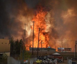
About 1,000 people were evacuated in western Canada, authorities said Thursday, as fires raged amid an unprecedented heat wave, charring most of at least one town.

The province of British Columbia has recorded 62 new fires in the past 24 hours, premier John Horgan told a press conference.

“I cannot stress enough how extreme the fire risk is at this time in almost every part of British Columbia,” Horgan said.

The town of Lytton, 250 kilometers (155 miles) northeast of Vancouver, “has sustained structural damage and 90 percent of the village is burned, including the centre of town,” local MP Brad Vis said.

The village’s 250 residents were evacuated on Wednesday evening, one day after it set a jaw-dropping Canadian record high temperature of 49.6 degrees Celsius (121 degrees Fahrenheit).

The evacuation order was extended Wednesday night to residents of about 100 properties north of Lytton.

“The last 24 hours have been devastating for Lytton residents,” Defence Minister Harjit Sajjan wrote on Twitter, adding that the Canadian armed forces “are ready to support residents as we move forward in the next steps.”

Provincial authorities have not yet announced any injuries or death related to the fires, a number of which were also clustered north of the city of Kamloops, located some 150 kilometers northeast of Lytton.

Early Thursday evening, British Columbia fire authorities said the unprecedented hot and dry conditions had led them to expect another difficult day ahead.

https://www.terradaily.com

Drought Indicators in Western U.S. Flash Warnings of the ‘Big One’

Brian K Sullivan and Elizabeth Elkin – June 24, 2021

(Bloomberg) — Sarah Brunner opened the irrigation spigots on her farm in March, three months early. The rain should have still been falling in California. Now that summer is taking hold, she and her husband are considering shifting their meager water supplies into pastures so their animals will have enough to eat.

Brunner’s worries don’t stop at the barnyard. The family’s fields of shallots, garlic and goats are surrounded by thick Northern California forests, dried out and primed to burn. An early season wildfire near her home recently prompted Brunner to document her possessions and reevaluate her fire insurance. “I don’t feel safe anymore. It’s going to hit us hard,” she says. “There’s no doubt about it, we’re going to be inundated with fires. It’s just a matter of time.”

Drought in a habitat shared with bears, cougars and coyotes, all searching for a drink, has a way of compounding the danger. “The animals are going to get more desperate,” Brunner says.

Unstoppable drought is rolling over California and the Western U.S. once again, as it has with little interruption since the new century began. Nearly 98% of land across 11 Western states is abnormally dry, and more than 90% is covered by some category of drought—the worst levels in the U.S. Drought Monitor’s 21-year history. Reservoirs have drained to their bottoms, leaving bath-tub rings on their shorelines. Rivers reduced to trickles are setting off conflicts for dwindling water rights. Millions of acres of trees and shrubs have turned from shade to fuel for the out-of-control blazes everyone predicts will come.

“As far as drought goes, this is the big one, especially if we are talking about the broader drought across the whole Southwest,” says Daniel Swain, a climate scientist at the University of California Los Angeles. “By a lot of metrics, it is the most severe drought on record.”

https://finance.yahoo.com

Shallow M6.1 earthquake hits Seram Island, Indonesia – tsunami warning issued

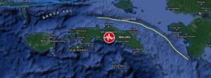
A shallow earthquake registered by the Indonesian BMKG as M6.1 hit Seram Island, Moluccas, Indonesia at 04:43 UTC (11.43 LT) on June 16, 2021. The agency is reporting a depth of 10 km (6.2 miles). EMSC and USGS are reporting M5.8 at a depth of 10.6 km (6.6 miles).

The epicenter was located 70.6 km (43.9 miles) ESE of Amahai (population 47 653) and 147 km (91.3 miles) E of Ambon (population 355 596), Maluku, Indonesia.

There are 300 000 people living within 100 km (62 miles).

9 000 people are estimated to have felt moderate shaking and 278 000 light, according to the USGS.

The Indonesian Agency for Meteorology, Climatology and Geophysics (BMKG) warned of possible aftershocks and tsunami potential, especially to Seram Island. “Please move away from beaches and move to higher ground,” BMKG said.

While the agency initially said there was no tsunami potential, it later said a tsunami wave could potentially be triggered by landslides.

“The results of tsunami modeling with a tectonic earthquake source showed that this earthquake has no tsunami potential, but based on observations of sea level… it showed the sea level rose as high as 0.5 m (1.6 feet),” BMKG said.

Residents along the coast of Tehoru panicked and ran up nearby hills when the sea started rising, but many have since returned home.

Local officials said some buildings sustained damage like cracked walls and windows, but there were no reports of injuries or casualties.

https://watchers.news

The Shaking In California Is Getting WORSE As Hundreds And Hundreds Of Earthquakes Cause Alarm On The West Coast

– June 6, 2021

Are we getting close to a major seismic event on the west coast?  Within the past several days, we have seen hundreds of earthquakes happen in southern California, there have been large earthquakes offshore near the Cascadia Subduction Zone, and there has been a very alarming swarm of earthquakes at Mt. Hood.  We haven’t seen this much seismic activity along the west coast in quite a long time, and many are concerned that this could be leading up to something really big.

At this moment, scientists are carefully monitoring the area around the Salton Sea.  According to the USGS, in one 24 hour period over the weekend more than 600 earthquakes of at least magnitude 1.0 shook that area of southern California…

More than 600 small earthquakes have been recorded this weekend in a rural area near the Salton Sea in Southern California, with the largest having a magnitude of 5.3, a US Geological Survey geophysicist told CNN.

Geophysicist Randy Baldwin said 603 temblors with a magnitude of at least 1 happened in the area from Saturday to just before sunrise Sunday.

The magnitude 5.3 quake was felt throughout the region.

In fact, it is being reported that it was even felt at an apartment building that was 95 miles away from the epicenter of the earthquake…

People in Chula Vista, San Diego, El Centro and Indio felt the 5.3 quake, according to the USGS, Did You Feel It reports. The tool collects information from people who report they’ve felt an earthquake and creates an interactive map.

Saturday morning’s shaking could be felt in an apartment building near Del Mar, California, approximately 95 miles away from the location of the earthquake.

When I wrote about the alarming rise of earthquake activity on the west coast a week ago, just over 1,000 earthquakes had occurred in California and Nevada over the previous seven days.

Now that number is up to 1,757, and it seems to be going up with each passing hour.

http://endoftheamericandream.com

Another worrying earthquake swarm hits Lake Tahoe – Scientists concerned about the potential for a tsunami

Strange Sounds – May 28, 2021

At least six earthquakes, including one with a preliminary magnitude of 4.2, shook the Lake Tahoe, Reno and Carson City area early on Friday, according to the U.S. Geological Survey.

The strongest one struck near the north end of the lake at Dollar Point, Calif., around 8:30 a.m. Pacific Daylight Time. There were no immediate reports of damage.

It came as Lake Tahoe’s resorts and tourist destinations prepared for a Memorial Day holiday that they hope will help lift the pall of the coronavirus pandemic and as legislators in Nevada’s capital met in early sessions to finish business before heading home for a long weekend.

It was also the latest in a series of quakes that had seismologists watching the Lake Tahoe area closely, concerned that a bigger quake could create a tsunami.

https://strangesounds.org

Congo’s Mount Nyiragongo Volcano Destroys Hundreds of Homes; At Least 15 Dead

Ron Brackett – May 24, 3021

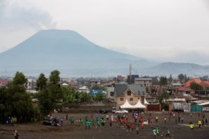
A river of lava a half-mile wide gushing from Congo’s Mount Nyiragongo engulfed hundreds of homes and set fires before coming to rest at the edge of the city of Goma.

Tens of thousands of people fled late Saturday as the volcano unleashed the lava flow that cast a scarlet glow in the night sky. It was the first time Mount Nyiragongo has erupted in nearly 20 years.

“The sky has turned red,” Carine Mbala, a resident of Goma, told AFP by telephone. “There is a smell of sulfur. In the distance you can see giant flames coming out of the mountain.”

At least 15 people died, most in car crashes in the chaotic evacuation, the Associated Press reported. UNICEF, the U.N. children’s agency, said more than 170 children were still feared missing.

When the volcano began erupting, some people boarded boats on Lake Kivu, which lies on the border between Congo and Rwanda in central Africa. About 5,000 people crossed the border into Rwanda. Another 25,000 went northwest toward the town of Sake, according to UNICEF.

Altogether, 17 villages were affected by the lava, government spokesman Patrick Muyaya said in a statement, according to Reuters. Three health centers, a primary school and a water pipeline were destroyed, he said.

https://weather.com

Wildfires burning at extremely dangerous levels across Manitoba, Canada

 – May 20, 2021

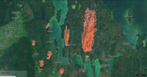
Wildfires are blazing out of control across Manitoba, Canada, some of which have caused evacuations. As of Wednesday, May 19, 2021, the government reported 12 fires at extremely dangerous levels, prompting air-quality warnings for the western and central areas due to smoke.

The biggest fire reported is in Homebrook, estimated to be 144 000 ha (355 800 acres), more than 80 km (50 miles) long, and roughly 16 km (10 miles) wide at its widest point.

“Important value protection efforts [are] underway to preserve the Manitoba Hydro Bi Pole Lines 1 and 2,” the Manitoba Government wrote on its 10th Fire Bulletin.

Smoke from the fire could affect a number of communities in the area, including Grand Rapids, Misapawistik Cree Nation, Homebrook, Skownan First Nation, Waterhen, Mallard, and Gypsumville.

The second-largest fire is in the Rural Municipality of Mountain South, estimated to be 7 000 ha (17 300 acres). The fire is posing risk to half a dozen properties, but work is underway to protect them and local crews are responding.

The third biggest fire is reported in the Spruce Woods Provincial Park, estimated at 5 600 ha (13 800 acres), which prompted a local state of emergency in the rural municipality of North Cypress and Carberry.

“There is also potential for smoke to affect Spruce Woods Provincial Park and Swan Lake First Nation,” wrote the government. “The Spirit Sands Trails in the Carberry desert are closed.”

“Hikers are urged to avoid the area and should not ignore closed trail signs. The suppression effort continues jointly between the Department of National Defense from Shilo, Manitoba Wildfire Service, and local authorities.”

https://watchers.news

Sinkhole drains lake near St-Louis, Missouri – Major Memphis bridge cracked – Is the New Madrid waking up?

Strange Sounds – May 13, 2021

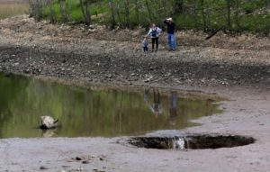
Lone Elk Park in St. Louis County has a leaky lake — and an SUV-sized sinkhole that opened up there in recent days has drained about a third of it.

St. Louis County Parks Director Tom Ott said he got word Friday that the lake had dropped about 3 feet, and then enough water drained away over the weekend to reveal the sinkhole.

This isn’t the first time this has happened at the manmade lake, called the Lone Elk Reservoir, said Ott. In 2016, a similar sinkhole about 4 to 5 feet across appeared in the vicinity of the new one. Then, they had someone inspect it and had concrete slurry poured into the hole to patch it.

The county will get a hydraulic engineer to look at the sinkhole, and will send someone with a drone to take pictures of it. They’ll also add signage along the shoreline to warn people to keep away.

Ott wonders if a small-magnitude earthquake reported near Eureka on April 20 shook anything loose.

He said that in the early 1990s the lake was always full, but in the past 20 years it hasn’t held water the way it should. “We’ve had people look at it — they couldn’t tell where it was leaking,” he said.

Meanwhile, all lanes on the Hernando Desoto Bridge were closed Tuesday until further notice after an inspection found a crack that requires investigation.

Memphis Police said the bridge is being inspected, and it is unknown when the I-40 bridge will reopen. It could be closed for month…

Right now, drivers can use the Interstate 55 bridge to cross the Mississippi River.

Now, if you add to this giant sinkhole, the shutdown of the I-40 bridge in downtown Memphis due to infrastructure damage and the hacked (?) pipeline… Are these more signs of the overdue New Madrid earthquake?

https://strangesounds.org

Dust storms and valley fever in the American West

Lia Potee – May 07, 2021

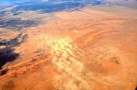
Valley fever is a dangerous threat to human health – and cases are on the rise in the arid southwestern United States, as wind from increasing dust storms can transport the fungal spores that cause the disease. Valley fever is caused by the Coccidioides fungus, which grows in dirt and fields and can cause fever, rash and coughing. Using NASA research and satellite data, the World Meteorological Organization is refining its Sand and Dust Storm Warning Advisory and Assessment System to help forecast where dust risk is greatest.

George Mason University’s Daniel Tong, one of the first scientists to discover the link between dust storms and Valley fever, leads a NASA-funded team to track the airborne spread of Valley fever across the United States for the first time.

There are about 15 thousand cases of Valley fever in the U.S. each year, and approximately 200 deaths, according to the U.S. Centers for Disease Control (CDC). Funded by NASA’s Earth Science Division, Tong’s team is helping track disease risk for epidemiologists, health care providers and public health decision makers.

“Our paper was the first one to reveal the positive relationship between dust storms and Valley fever,” said Tong. “So now we’re asking the question: How can we detect that dust in the air?”

https://www.terradaily.com