Major M7.4 earthquake hits near the coast of Fukushima Prefecture, Japan

– March 16, 2022

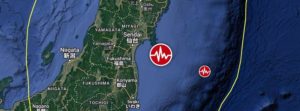
A major earthquake registered by the Japan Meteorological Agency (JMA) as M7.4 hit near the coast of Fukushima Prefecture at 14:36 UTC (23:36 JTC) on March 16, 2022. The agency is reporting a depth of 60 km (37 miles). USGS is reporting M7.3 at a depth of 33 km (20 miles), EMSC M7.2 at a depth of 80 km (49 miles). The quake was preceded by M6.4 at 14:34 UTC at a depth of 56 km (35 miles).

The epicenter was located about 66 km (41 miles) ENE of Namie (population 21 866), Fukushima and 96 km (59 miles) SE of Sendai (population 1 063 103), Miyagi, Japan.

There are about 1.8 million people living within 100 km (62 miles).

JMA has issued a Tsunami Advisory for the Fukushima and Miyagi prefectures, with waves up to 1 m (3.3 feet) expected. A Tsunami Forecast is in effect for most of Japan’s eastern coastal areas.

2 046 000 people are estimated to have felt very strong shaking, 3 200 000 strong and 7 379 000 moderate.

The USGS issued a Green alert for shaking-related fatalities. There is a low likelihood of casualties.

A Yellow alert was issued for economic losses. Some damage is possible and the impact should be relatively localized. Estimated economic losses are less than 1% of GDP of Japan. Past events with this alert level have required a local or regional level response.

Overall, the population in this region resides in structures that are resistant to earthquake shaking, though vulnerable structures exist. The predominant vulnerable building types are heavy wood frame and reinforced/confined masonry construction.

Recent earthquakes in this area have caused secondary hazards such as tsunamis, landslides and fires that might have contributed to losses.

Updates

The earthquake has left 4 people dead and more than 160 injured. (Mainichi)

The quake caused power outages in northeastern and eastern Japan, affecting a total of more than 2.2 million households, including some 700 000 in Tokyo. Power was later restored to most of the affected citizens.

The country’s nuclear regulator said data show no abnormalities with reactors and facilities at the Fukushima Daiichi nuclear power plant, although the cooling system for the spent fuel pools at the No. 2 and No. 5 reactors temporarily stopped. Cooling systems for spent fuel pools at the Fukushima Daini nuclear power plant and the Onagawa nuclear plant in Miyagi were also affected before recovering.

A Tohoku Shinkansen bullet train derailed between Fukushima Station and Shiroishizao Station, but all 78 passengers and crew members aboard were unharmed, according to East Japan Railway Co.

Relatively small tsunami waves were observed at Ishinomaki port in Miyagi and other locations.

https://watchers.news

Strong 5.7 earthquake rattles southern Mexico sending people fleeing into the streets in panic

Ricky Scaparo – March 3, 2022

An earthquake struck southeast Mexico on Thursday, sending people fleeing into the streets. The U.S. Geological Survey gave a preliminary magnitude of 5.7 and said the epicenter was about 7 miles (12 kilometers) west-northwest of the town of Nopalapan at a depth of 69 miles (111 kilometers).

The quake triggered seismic alarms 235 miles (380 kilometers) away in Mexico City, but it was not felt in the capital. There were no immediate reports of damage.

The motion of these crustal plates causes frequent earthquakes and occasional volcanic eruptions. Mexico has a long history of destructive earthquakes and volcanic eruptions, according to the U.S. Geological Survey. In September 1985, a magnitude 8.0 earthquake killed more than 9,500 people in Mexico City.

https://endtimeheadlines.org

Hidden M8.2 earthquake triggers mysterious 2021 global tsunami

Strange Sounds – February 9, 2022

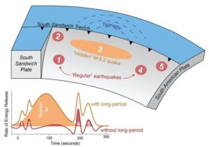
Scientists have uncovered the source of a mysterious 2021 tsunami that sent waves around the globe. A magnitude 8.2 earthquake was “hidden” within a magnitude 7.5 earthquake in 2021, sending a mysterious tsunami around the world.

In August 2021, a magnitude 7.5 earthquake hit near the South Sandwich Islands, creating a tsunami that rippled around the globe. The epicenter was 47 kilometers below the Earth’s surface — too deep to initiate a tsunami — and the rupture was nearly 400 kilometers long, which should have generated a much larger earthquake.

Seismologists were puzzled and sought to understand what really happened that day in the remote South Atlantic.

A new study revealed the quake wasn’t a single event, but five, a series of sub-quakes spread out over several minutes. The third sub-quake was a shallower, slower magnitude 8.2 quake that hit just 15 kilometers below the surface. That unusual, “hidden” earthquake was likely the trigger of the worldwide tsunami.

The study was published in the AGU journal Geophysical Research Letters, which publishes short-format, high-impact papers with implications that span the Earth and space sciences.

Because the South Sandwich Islands earthquake was complex, with multiple sub-quakes, its seismic signal was difficult to interpret, according to lead study author Zhe Jia, a seismologist at the California Institute of Technology. The magnitude 8.2 quake was hidden within the tangle of seismic waves, which interfered with each other over the course of the event. The hidden quake’s signal wasn’t clear until Jia filtered the waves using a much longer period, up to 500 seconds. Only then did the 200-second-long quake, which Jia said accounted for over 70% of the energy released during the earthquake, become clear.

“The third event is special because it was huge, and it was silent,” Jia said. “In the data we normally look at [for earthquake monitoring], it was almost invisible.”

Predicting hazards for complex earthquakes can be difficult, as the South Sandwich Islands quake demonstrates. The USGS initially reported the magnitude 7.5 quake and only added the 8.2 event the following day, as the surprise tsunami lapped on shores up to 10,000 kilometers away from its point of origin.

“We need to rethink our way to mitigate earthquake-tsunami hazards. To do that, we need to rapidly and accurately characterize the true size of big earthquakes, as well as their physical processes,” Jia said.

https://strangesounds.org

Preparedness: A monstrous earthquake in the Pacific Northwest is a certainty; we just don’t know when

Strange Sounds – January 27, 2022

A monstrous earthquake in the Pacific Northwest is a certainty. We just don’t know when.

For many people, natural disasters inspire both fascination and fear. They’re a sign of nature’s power to not only create, but also destroy. At the same time, they’re a reminder of the human potential for ingenuity when it comes to protecting ourselves from the forces we cannot control.

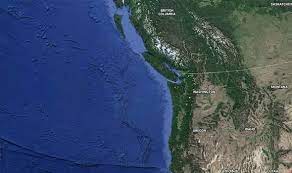
In this case, there are two opposing forces: the North American Plate, an enormous tectonic plate that carries the entire continental United States on its back, versus the 90,000-square-mile Juan de Fuca Plate, located in the ocean off Washington, Oregon, and Northern California.

For the past 200 million years, these two have been squaring off in an epic wrestling match in an area known as the Cascadia Subduction Zone, or CSZ. Trust us, nobody wants to see the end of this round. Yet only a few people seem truly bothered: seismologists, emergency management professionals, and those who have experienced earthquakes before.

It’s certain that the Northwest will experience a devastating earthquake again, says Chris Goldfinger, an oceanographer at Oregon State University and one of the world’s leading experts on subduction zone earthquakes. “We have no idea of the timing and how urgent it is,” Goldfinger tells Pop Mech. “People tend to ignore it in that case.

The majority of the public, as well as most governments in the Northwest, aren’t yet pushing to implement the extensive infrastructure changes and early-warning communications systems needed to save tens of thousands of lives.

The Juan de Fuca Plate has been steadily pushing against the Pacific Coast as it slides beneath the North American Plate. But the roughly 47-million-square-mile North American Plate isn’t budging. Instead, it’s locked tightly against the Juan de Fuca’s surface.

Here’s the chilling prediction from the Cascadia Region Earthquake Workgroup (CREW) in its 2013 report on CSZ earthquakes: “Cascadia has now been building up strain for over 300 years, so the next great earthquake could happen at any time.

https://strangesounds.org

What In The World Is Happening To Our Planet? One Of The Most Catastrophic Disasters In Modern History Should Be A Wake Up Call For All Of Us

– January 16, 2022

Why does our planet keep getting hit by “historic disaster” after “historic disaster”?  Over the past couple of years, an extremely unusual series of hurricanes, tornadoes, droughts, floods, earthquakes and volcanic eruptions has rocked the globe.  Authorities keep telling us that “everything is normal”, but the truth is that there is absolutely nothing about any of this that is “normal”.  Major changes appear to be happening to our planet, and that has enormous implications for our future.

Unfortunately, the corporate media gives very little attention to the major disasters that take place outside of the United States, and so most Americans don’t even understand the seriousness of what we are facing.

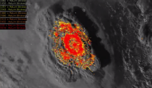
Over the weekend, the Hunga Tonga-Hunga Ha’apai volcano in Tonga experienced a “once in a thousand years explosion”.  This eruption sent a 3 mile wide mushroom cloud of red hot ash, steam and gas 12 miles into the air.

To put that in perspective, the entire island of Manhattan is only 2.3 miles wide.

This eruption was so massive that it actually created an entirely new island, and the sonic boom from the blast could be heard 6000 miles away in Alaska.

One of the most remarkable things about this disaster is the incredible amount of volcanic lightning that it produced.

It is being reported that there were approximately “200,000 lightning events” during the first hour of the eruption alone.

http://theeconomiccollapseblog.com

Experts baffled by continuing South Carolina earthquakes – Will they lead to more serious and damaging seismic activity?

Strange Sounds – January 5, 2022

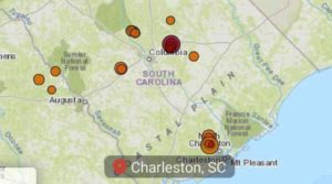
Yet more earthquakes have struck near South Carolina’s capital city, the ninth and tenth in a series of rumblings that have caused geologists to wonder how long the convulsions might last, or if they could possibly portend future, more serious seismic activity.

Early Wednesday, a 2.6-magnitude earthquake struck near Elgin, about 25 miles (40 kilometers) northeast of Columbia, according to the U.S. Geological Survey. It was measured at a depth of 0.5 kilometers, officials said. About 7 hours later, another earthquake hit the area, this one with a magnitude of 1.5, according to officials.

That area, a community of fewer than 2,000 residents near the border of Richland and Kershaw counties, has become the epicenter of a spate of recent seismic activity, starting with a 3.3-magnitude earthquake on Dec. 27. That quake clattered glass windows and doors in their frames, sounding like a heavy piece of construction equipment or concrete truck rumbling down the road.

Since then, a total of nine more earthquakes have been recorded nearby, ranging from 1.5 to Wednesday morning’s 2.6 quake. No injuries or damage have been reported.

https://strangesounds.org

Major M7.3 earthquake triggers hazardous tsunami warning, cracks roads and destroys buildings in Indonesia – People run out of homes screaming out loud

Strange Sounds – December 14, 2021

An undersea earthquake of magnitude 7.3 has struck off the coast of Indonesia’s Flores Island, prompting the country’s monitoring agency to issue a tsunami warning which was later called off.

The US Geological Survey said that the quake occurred at a depth of 18.5km under the sea and was located 112km north of the second-largest island town in East Nusa Tenggara province.

The casualties from the undersea earthquake are not immediately clear. However, authorities said several buildings and public properties suffered damage as photos showed roads cracked open by the temblor.

Another photo by local media showed a wall demolished due to the impact of the quake and bricks strewn on the road in South Sulawesi.Almost two hours after the quake, Indonesia’s Meteorology, Climatology, and Geophysical Agency agency called off the tsunami warning but asked locals in East Nusa Tenggara and South Sulawesi to remain vigilant.

Hazardous tsunami waves are possible for coasts located within 1,000km of the epicentre, the US-based Pacific Tsunami Warning Centre had said in the initial warning.

Preliminary visuals from the island nation showed people rushing out of their homes, away from the sea and running towards safe areas.

Everyone ran out into the street,” according to a resident of Maumere town on Flores island.

https://strangesounds.org

U.S. Government Continues To Panic Over Mild Omicron

Mac Slavo – December 2, 2021

The Centers for Disease Control and Prevention (CDC) has confirmed that the United States government is set to impose new Covid restrictions on travelers. These new control measures will require a negative test within one day of travel for all arrivals, including vaccinated people.

That means that even those who bowed down to the state and big pharma dutifully got injected two or even three times, will still have to live through the same draconian dictatorship as the unvaccinated. The move comes after the CDC confirmed America’s first case of the Omicron variant in California in an individual who arrived from South Africa on November 22, according to RT. The fully vaccinated traveler later tested positive on November 29 after showing mild symptoms.

Has anyone wondered yet why omicron is only popping up in the vaccinated?

More COIVD-19 Vax Deaths: Think They’ll Blame This On COVID-21?

Nonetheless, the ruling class has decided that the unvaccinated need not travel. Currently, the United States denies entry to all unvaccinated individuals from other countries, while fully inoculated people who have received approved vaccines can travel to America if they provide a negative Covid test taken within three days of arrival. The CDC also encourages vaccinated individuals to take a test on the third to the fifth day after they enter the US.

All this testing is going to do is boost the numbers and increase the fear of this cold. This is all coming to a head, and we could begin to see the real plans taking shape in the coming months.

https://www.shtfplan.com

Powerful M7.5 earthquake hits northern Peru

– November 28, 2021

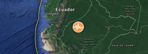
A major earthquake registered by the USGS as M7.5 hit a very sparsely populated region of northern Peru at 10:52 UTC on November 28, 2021. The agency is reporting a depth of 112.5 km (69.9 miles). EMSC is reporting M7.5 at a depth of 110 km (68.3 miles).

The epicenter was located 43 km (27 miles) NNW of Barranca (population 5 779), and 173 km (107 miles) N of Moyobamba (population 44 276), Peru.

27 000 people are estimated to have felt severe shaking, 127 000 very strong, 1 090 000 strong, and 4 343 000 moderate.

The USGS issued a Yellow alert for shaking-related fatalities and economic losses. Some casualties and damage are possible and the impact should be relatively localized. Past yellow alerts have required a local or regional level response.

Estimated economic losses are less than 1% of GDP of Peru.

Overall, the population in this region resides in structures that are highly vulnerable to earthquake shaking, though some resistant structures exist. The predominant vulnerable building types are mud wall and reinforced/confined masonry construction.

USGS estimated limited number / and (or) spatial extent of landslides triggered by this earthquake. The number of people living near areas that could have produced landslides in this earthquake is low, but landslide damage or fatalities are still possible in highly susceptible areas.

Liquefaction triggered by this earthquake is estimated to be extensive in severity and (or) spatial extent and the number of people living near areas that could have produced liquefaction in this earthquake is significant.

https://watchers.news

Earthquake warning as US and Canada ‘due for major event’: ‘It’s matter of when’

Joel Day – November 5, 2021

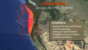
It has been centuries since the contiguous US, the entirety of the states, experienced a “Big One” — an earthquake with a magnitude greater than 9.0. The last on record was an earthquake in 1700 with an estimated magnitude of 9.0. This was along the Cascadia subduction zone where the Juan de Fuca plate is diving underneath the North American plate.

Huge earthquakes happen in this region because the plate that’s going down is usually oceanic crust, which is cold and dense, which means it can break in a sharp and sudden manner.

However, the cold dense crust that’s sinking can break for a much longer time and initially result in the seismic shifts and tremors.

The nature of the zone pairs any earthquake with another destructive event: a tsunami.

The earthquake that hit in 1700 sent a tsunami across the Pacific Ocean as far as Japan.

Researchers are now expecting another event at the Cascadia subduction zone, with the chances of it happening in the coming decades explored during NOVA PBS’ short documentary, ‘The Pacific Northwest is due for a Major Earthquake’.

Wendy Bohon, a geologist and senior science communication specialist at the Incorporated Research Institutions for Seismology, explained the process behind how a tsunami would result from an earthquake, and said: “You have one plate diving down beneath another, one section gets locked and it pushes another part up.

“When the fault ruptures, when the amount of stress overcomes the friction, it bounces back, which lifts up the water above it and causes that water to flow out in all directions.

“And that water flowing out in all directions in the tsunami.”

Oral histories of the earthquake and tsunami that hit in 1700 suggest many died from the event.

https://www.express.co.uk