Montana in grip of 4th driest year on record: Big Sky Country farmers, ranchers and towns struggle under extreme drought

Strange Sounds – December 22, 2021

There’s an old weather adage that’s been passed over cups of coffee and glasses of beer for nearly a century: “It’s not a drought ’til it breaks your heart.”

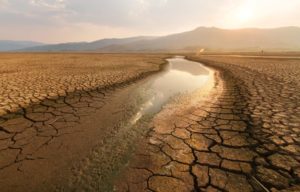
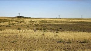
Today, the hearts of thousands of Montanans have broken across the bare back of one of one of the worst droughts in Montana history: farmers trying to balance their books after a paltry harvest, stockmen paying too much to feed already skinny cattle, outfitters and fishermen prevented from landing a fish because the streams were either too warm or too dry, conservationists and recreationists of all types who watched Montana’s forests burn and its prairies shrivel.

On Dec. 15, 2021, every county in Montana was identified as experiencing some level of drought, with a third of the state is in the grips of a “D4” or “exceptional” drought, a designation the U.S. Department of Agriculture expects to occur in any one location just once every 50 to 100 years. The entire state is, on average, 4.66 inches behind in annual precipitation. The only years that have been drier were 1931, 1919 and 1952.

There have been longer droughts, both in the first half of the 1930s and again in the early 2000s, and isolated portions of Montana have withered under more extreme stretches of heat and dryness for limited periods of time, but according to the National Centers for Environmental Information (NCEI) in only three of the past 127 years have Montanans as a whole endured such bone dry conditions.

https://strangesounds.org

Major M7.3 earthquake triggers hazardous tsunami warning, cracks roads and destroys buildings in Indonesia – People run out of homes screaming out loud

Strange Sounds – December 14, 2021

An undersea earthquake of magnitude 7.3 has struck off the coast of Indonesia’s Flores Island, prompting the country’s monitoring agency to issue a tsunami warning which was later called off.

The US Geological Survey said that the quake occurred at a depth of 18.5km under the sea and was located 112km north of the second-largest island town in East Nusa Tenggara province.

The casualties from the undersea earthquake are not immediately clear. However, authorities said several buildings and public properties suffered damage as photos showed roads cracked open by the temblor.

Another photo by local media showed a wall demolished due to the impact of the quake and bricks strewn on the road in South Sulawesi.Almost two hours after the quake, Indonesia’s Meteorology, Climatology, and Geophysical Agency agency called off the tsunami warning but asked locals in East Nusa Tenggara and South Sulawesi to remain vigilant.

Hazardous tsunami waves are possible for coasts located within 1,000km of the epicentre, the US-based Pacific Tsunami Warning Centre had said in the initial warning.

Preliminary visuals from the island nation showed people rushing out of their homes, away from the sea and running towards safe areas.

Everyone ran out into the street,” according to a resident of Maumere town on Flores island.

https://strangesounds.org

Oregon’s most active fault continues to “build up” with earthquake swarm continuing

Ricky Scaparo – December 12, 2021

Upwards of 60 earthquakes have been recorded off the Oregon coast – starting Tuesday and continuing through Wednesday. The quakes occurred along the Blanco Fault Zone –Oregon’s most active fault according to KOIN.

The biggest reached a magnitude of 5.8. Despite the number of quakes, experts say there’s no cause for concern as it’s commonplace for earthquake swarms to occur in this zone, KOIN 6 News Chief Meteorologist Natasha Stenbock said.

KIRO7 states that nearly 250 miles west of Newport, Oregon, a place called the Blanco Fracture Zone has produced more than 60 earthquakes in 36 hours. “About 20 of them, oh, we just had another one just now, about 21 of them are over magnitude 4.7,” said Chris Goldfinger of Oregon State University.

Goldfinger said offshore swarms of earthquakes happen around once a year. “They’re called strike-slip earthquakes where the two blocks move side by side, so because there’s not a lot of vertical motion, they don’t generate tsunamis,” he said.

https://endtimeheadlines.org

Powerful M7.5 earthquake hits northern Peru

– November 28, 2021

A major earthquake registered by the USGS as M7.5 hit a very sparsely populated region of northern Peru at 10:52 UTC on November 28, 2021. The agency is reporting a depth of 112.5 km (69.9 miles). EMSC is reporting M7.5 at a depth of 110 km (68.3 miles).

The epicenter was located 43 km (27 miles) NNW of Barranca (population 5 779), and 173 km (107 miles) N of Moyobamba (population 44 276), Peru.

27 000 people are estimated to have felt severe shaking, 127 000 very strong, 1 090 000 strong, and 4 343 000 moderate.

The USGS issued a Yellow alert for shaking-related fatalities and economic losses. Some casualties and damage are possible and the impact should be relatively localized. Past yellow alerts have required a local or regional level response.

Estimated economic losses are less than 1% of GDP of Peru.

Overall, the population in this region resides in structures that are highly vulnerable to earthquake shaking, though some resistant structures exist. The predominant vulnerable building types are mud wall and reinforced/confined masonry construction.

USGS estimated limited number / and (or) spatial extent of landslides triggered by this earthquake. The number of people living near areas that could have produced landslides in this earthquake is low, but landslide damage or fatalities are still possible in highly susceptible areas.

Liquefaction triggered by this earthquake is estimated to be extensive in severity and (or) spatial extent and the number of people living near areas that could have produced liquefaction in this earthquake is significant.

https://watchers.news

La Palma volcanic eruption update: New vent, new very fast lava flow, 4 new cone collapses, powerful jets and all flights cancelled, yellow warning due to heavy rains

Strange Sounds – November 25, 2021

Today, the eruption is more powerful than the last several days.

The main cone also collapsed at least 4 times between Thursday and early Friday, thus increasing the flow of lava. Moreover, a new vent has opened on the southern part of the main cone of the La Palma volcano early this evening.

As a consequence, a new stream of very liquid and fast moving magma has formed. The new lava flow emerging from the new fissure runs at 600m/hour through new territory in urbanized areas.

The new front has already covered the Las Manchas cemetery (area of ​​more than 1,000 square meters; more than 5,000 niches and the only crematorium on the island).

Meanwhile, State Meteorological Agency (Aemet) has issued a weather yellow warning. The authorities of La Palma have announced that this Friday access to the highway to the south of the island will be closed due to the risk of runoff and landslides due to the expected heavy rains.

All flights to and from La Palma have been cancelled.

https://strangesounds.org

Agricultural disaster after record rains cause catastrophic floods in British Columbia, Canada

British Columbia has declared a state of emergency on November 17, 2021, after several days of heavy rain caused catastrophic floods in parts of the province. At least 1 person has been killed but officials fear the death toll will rise.

Another atmospheric river event hit British Columbia and parts of the U.S. Northwest over the past weekend, dropping record-breaking rain. Parts of the region received more than 2 months of average rainfall in just 48 hours, causing rivers to overflow and low-lying plains to flood.1

The resulting floods destroyed roads and bridges, submerged homes and farmland, leaving at least 1 person dead.

B.C. Agriculture Minister Lana Popham said hundreds of farms have been affected provincewide, many in the Fraser Valley. Nearly in tears, she described the widespread flooding as an agricultural disaster.2

The region has been one of the hardest hit by floods, with evacuation orders still in effect for the city of Abbotsford — home to roughly half of all the dairy farms in British Columbia.

In addition, thousands of animals have perished in the floods and the government says it will work to get veterinarians into farms to treat animals. Some of the animals that escaped the floods are expected to be euthanized.

Some highways were closed after numerous landslides, including Highway 7 from Hope to Vancouver where as many as 100 vehicles were trapped between two landslides.1

As of November 18, nearly 20 000 people are still out of their homes across the province.

https://watchers.news

Statewide crisis! 19 million people under drought emergency in Southern California – That’s nearly half of all California residents

Strange Sounds – November 12, 2021

Nearly half of all California residents are under a regional drought emergency as record dry conditions continue to exacerbate a statewide crisis.

The Metropolitan Water District of Southern California, a wholesaler to 26 local agencies that together supply some 19 million people with water, declared a state of emergency Tuesday in a resolution that calls for increased conservation efforts.

Last month, California Gov. Gavin Newsom expanded a statewide drought emergency, which authorizes the state water board to ban wasteful water uses, such as using potable water for washing sidewalks and driveways.

Tuesday’s declaration, which also pertains to businesses, supports Newsom’s proclamation, activates additional conservation efforts and expands water efficiency programs.

We need immediate action to preserve and stretch our limited State Water Project supplies,” board Chairwoman Gloria D. Gray said in a statement. “Southern California on average gets about one-third of its water from Northern California via the state project. Next year, we’ll be lucky to get a small fraction of that.

The declarations come as California struggles with unprecedented dry conditions and an ongoing strain on state water resources. California’s last two water years were the driest two-year period on record for precipitation. In August, Lake Oroville — the main reservoir in the State Water Project — reached its lowest point since the 1970s.

https://strangesounds.org

Earthquake warning as US and Canada ‘due for major event’: ‘It’s matter of when’

Joel Day – November 5, 2021

It has been centuries since the contiguous US, the entirety of the states, experienced a “Big One” — an earthquake with a magnitude greater than 9.0. The last on record was an earthquake in 1700 with an estimated magnitude of 9.0. This was along the Cascadia subduction zone where the Juan de Fuca plate is diving underneath the North American plate.

Huge earthquakes happen in this region because the plate that’s going down is usually oceanic crust, which is cold and dense, which means it can break in a sharp and sudden manner.

However, the cold dense crust that’s sinking can break for a much longer time and initially result in the seismic shifts and tremors.

The nature of the zone pairs any earthquake with another destructive event: a tsunami.

The earthquake that hit in 1700 sent a tsunami across the Pacific Ocean as far as Japan.

Researchers are now expecting another event at the Cascadia subduction zone, with the chances of it happening in the coming decades explored during NOVA PBS’ short documentary, ‘The Pacific Northwest is due for a Major Earthquake’.

Wendy Bohon, a geologist and senior science communication specialist at the Incorporated Research Institutions for Seismology, explained the process behind how a tsunami would result from an earthquake, and said: “You have one plate diving down beneath another, one section gets locked and it pushes another part up.

“When the fault ruptures, when the amount of stress overcomes the friction, it bounces back, which lifts up the water above it and causes that water to flow out in all directions.

“And that water flowing out in all directions in the tsunami.”

Oral histories of the earthquake and tsunami that hit in 1700 suggest many died from the event.

https://www.express.co.uk

River Euphrates in Syria drying up, local populace affected

Sakina Fatima – September 5, 2021

Damascus: The drying up of Euphrates, Syria’s longest river is raising concerns as the demise of the water body could lead to a humanitarian disaster in the country. Millions of people in Syria are losing access to water, food and electricity.

The aid groups and engineers have expressed their concern at the possibility of a humanitarian disaster in northeastern Syria.

Rising temperatures, lower rainfall and drought across the region are depriving people of drinking water and agricultural water. This also disrupts electricity as dams run out, which in turn affects the operation of basic infrastructure, including health facilities. The rise in temperatures caused by climate change increase the risks and severity of droughts.

More than five million people in Syria directly depend on the river.

Khaled al-Khamees , a 50-year-old farmer from Rumayleh in Alepp Province, was financially affected when a creeping drought hit his land this year.

“We’re thinking of leaving because there’s no water left to drink or irrigate the trees,” Khamees told media.

Humanitarian groups in Syria also indicated that two out of three drinking water stations along the river has been pumping less water or has stopped working.

Even Iraq faces the same situation; the loss of access to water from the river and drought threatens at least seven million people.

https://www.siasat.com

California experiences driest water year in 100 years of record keeping

Ricky ScaparoOctober 19, 2021

In a year of both extreme heat and extreme drought, California has reported its driest water year in terms of precipitation in a century, and experts fear the coming 12 months could be even worse.

According to KTAL5 News, The Western Regional Climate Center added average precipitation that had been reported at each of its stations and calculated that a total of 11.87 inches of rain and snow fell in California in the 2021 water year.

That’s half of what experts deem average during a water year in California: about 23.58 inches. The climate center tallies rainfall by averaging all of the measured precipitation in the state at the end of a water year, which runs Oct. 1 through Sept. 30.

LA Times reported that the climate center tallies rainfall by averaging all of the measured precipitation in the state at the end of a water year, which runs Oct. 1 through Sept. 30.

Based on the diminished levels of both precipitation and runoff, the last water year was the second driest on record, according to the California Department of Water Resources. The last time the state reported so little rain and snowfall was in 1924.

Climatologists have compared the drought conditions that spanned 2020 and 2021 to the 1976-77 drought, which included California’s lowest level of statewide runoff in a single water year. The average rainfall in 1976-77 was 28.7 inches; in 2020-21, it was 28.2 inches.

https://endtimeheadlines.org