Earthquake rattles unusual location in Illinois, Precursor to New Madrid activity?

Ricky Scaparo – April 14, 2022

(OPINION) – Since we live near the New Madrid Fault, it’s normal to have earthquakes in our region. However, there was an earthquake that was felt by many that just happened in a weird part of Illinois.

According to the USGS, there was a 2.6 earthquake, but it wasn’t in the normal area near New Madrid. It was in the southeastern part of the state. This relatively tiny shaker occurred at 1:40 am early Wednesday morning, but was felt by 18 as of this writing.

Along with the non-typical location, it’s odd to me that a quake of only 2.6 magnitude would actually be felt in the middle of the night. A quake that small would be hard to detect even in the middle of the day if you were wide awake.

It’s close enough to what the USGS considers the New Madrid Fault Zone that it’s likely related to activity there. However, it’s just strange enough to pass along in case it’s the forerunner of something more major.

https://endtimeheadlines.org

Slow Slip Event on Cascadia Subduction Zone: Vancouver Island hit by more than 4,200 quakes since March 20 – Cascadia about to blow?

Strange Sounds – April 5, 2022

You can’t feel it, but the ground far beneath our feet on south-central Vancouver Island has been moving.

Seismologists have been recording thousands of “episodic tremor and slip events” occurring at a rapid rate since March 20 moving in a southeasterly direction down the Island.

More than 4,200 tiny tremors have been recorded so far between 25 and 40 kilometres below the surface, said John Cassidy, an earthquake seismologist with Natural Resources Canada and a professor at the University of Victoria.

They’re not earthquakes. … On the instruments they look like series of a trains rolling by,” Cassidy said.

He said these bursts of small tremors and slips occur about every 15 months along faults that form the boundaries of tectonic plates — in our case, the Cascadia subduction zone from Brooks Peninsula on the Island to Northern California, where the Juan de Fuca plate system curves west beneath the North American plate.

The repeated episodes of slow fault slips — measuring about the size of five stacked dimes — usually occur over a period of several weeks, accompanied by tremors that appear on seismic records as prolonged, intermittent ground vibrations, Cassidy said.

The ETS activity has been going on for centuries, but has only recently been recorded using sophisticated GPS technology at more than 40 sites up and down the Island. They differ from earthquakes, which generate large, sharp shock waves that subside very quickly, but ETS can help in improving estimates on where and when the next earthquake might occur, Cassidy said.

By mapping out the areas on the subduction fault where stress is not accumulating over the long term, tremor events define the landward limit of the zone that could rupture during the next great earthquake.

That provides a more accurate estimate of how close the rupture could be to major West Coast cities such as Victoria, Vancouver and Seattle, and what shaking could occur, he said.

https://strangesounds.org

Back to back powerful earthquakes strike southeast of the Loyalty Islands, New Caledonia

Ricky Scaparo – March 31, 2022

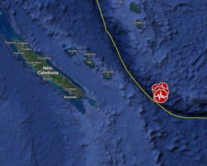
A very strong and shallow earthquake registered by the USGS as M7.0 struck southeast of the Loyalty Islands, New Caledonia according to a report from the Watchers, at 05:44 UTC on March 31, 2022. The agency is reporting a depth of 10 km (6.2 miles).

EMSC is reporting the same magnitude and depth. The quake was preceded by M6.9 (USGS) / M6.7 (EMSC) at 20:56 UTC on March 30, and a series of moderate to strong aftershocks. The epicenter was located about 280 km (174 miles) ESE of Tadine, New Caledonia, and 368 km (229 miles) SSE of Isangel, Vanuatu.

There are no people living within 100 km (62 miles). Based on all available data, hazardous tsunami waves are forecast for some coasts, NWS PTWC said. Tsunami waves are forecast to be less than 0.3 m (0.98 feet) above tide level for the coasts of Fiji, New Caledonia, and Vanuatu.

Actual amplitudes at the coast may vary from forecast amplitudes due to uncertainties in the forecast and local features. In particular maximum tsunami amplitudes on atolls and at locations with fringing or barrier reefs will likely be much smaller than the forecast indicates.

https://endtimeheadlines.org

Here Comes the Food Shortage!

Socialist takeovers always progress to the food shortage stage sooner or later. Remember reading in horror about how Venezuelans were gobbling up their zoo animals in an effort to remain alive? Seems like it was only yesterday. But since horsemen Pestilence and War have already galloped through, I guess Famine can’t be far behind.

Last fall, I wrote about a conversation I had with an escapee from a late-stage socialist country south of our border:

“Are you ready for the [something in Spanish]?” another socialism escapee asked me the other day.

“What does that mean?” I asked.

“The great hunger,” he replied.

I asked him how he knew that was coming, and he said he had seen the same process unfurl decades earlier in his homeland.

Earlier today, the hapless president of the United States emerged from one of his NATO huddles to answer questions from the reporters he had been instructed to call upon, as per his SOP. One of them brought up the potential for food shortages, and Biden’s answer was serious bad-feeling-in-the-pit-of-your-stomach material:

“With regard to food shortages, yes, we did [random sounds] talk about food shortages. And, uh, and it’s gonna be real. The price of these sanctions is not just imposed upon Russia, it’s imposed upon an awful lot of countries as well, including European countries and our country as well.”

Last I heard, sanctions were supposed to be a weapon one wields against one’s enemies. If you’re imposing sanctions and hurting yourself and your allies, you’re doing it wrong.

https://pjmedia.com

Major M7.4 earthquake hits near the coast of Fukushima Prefecture, Japan

– March 16, 2022

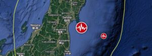
A major earthquake registered by the Japan Meteorological Agency (JMA) as M7.4 hit near the coast of Fukushima Prefecture at 14:36 UTC (23:36 JTC) on March 16, 2022. The agency is reporting a depth of 60 km (37 miles). USGS is reporting M7.3 at a depth of 33 km (20 miles), EMSC M7.2 at a depth of 80 km (49 miles). The quake was preceded by M6.4 at 14:34 UTC at a depth of 56 km (35 miles).

The epicenter was located about 66 km (41 miles) ENE of Namie (population 21 866), Fukushima and 96 km (59 miles) SE of Sendai (population 1 063 103), Miyagi, Japan.

There are about 1.8 million people living within 100 km (62 miles).

JMA has issued a Tsunami Advisory for the Fukushima and Miyagi prefectures, with waves up to 1 m (3.3 feet) expected. A Tsunami Forecast is in effect for most of Japan’s eastern coastal areas.

2 046 000 people are estimated to have felt very strong shaking, 3 200 000 strong and 7 379 000 moderate.

The USGS issued a Green alert for shaking-related fatalities. There is a low likelihood of casualties.

A Yellow alert was issued for economic losses. Some damage is possible and the impact should be relatively localized. Estimated economic losses are less than 1% of GDP of Japan. Past events with this alert level have required a local or regional level response.

Overall, the population in this region resides in structures that are resistant to earthquake shaking, though vulnerable structures exist. The predominant vulnerable building types are heavy wood frame and reinforced/confined masonry construction.

Recent earthquakes in this area have caused secondary hazards such as tsunamis, landslides and fires that might have contributed to losses.

Updates

The earthquake has left 4 people dead and more than 160 injured. (Mainichi)

The quake caused power outages in northeastern and eastern Japan, affecting a total of more than 2.2 million households, including some 700 000 in Tokyo. Power was later restored to most of the affected citizens.

The country’s nuclear regulator said data show no abnormalities with reactors and facilities at the Fukushima Daiichi nuclear power plant, although the cooling system for the spent fuel pools at the No. 2 and No. 5 reactors temporarily stopped. Cooling systems for spent fuel pools at the Fukushima Daini nuclear power plant and the Onagawa nuclear plant in Miyagi were also affected before recovering.

A Tohoku Shinkansen bullet train derailed between Fukushima Station and Shiroishizao Station, but all 78 passengers and crew members aboard were unharmed, according to East Japan Railway Co.

Relatively small tsunami waves were observed at Ishinomaki port in Miyagi and other locations.

https://watchers.news

Nearly 2.8 Million Birds (Mostly Chickens And Turkeys) Have Died In The First Month Of America’s Raging New Bird Flu Pandemic

– March 9, 2022

On top of everything else, now a highly pathogenic avian influenza pandemic is ripping across the United States, and it has already resulted in the deaths of almost 2.8 million birds.  Most of the birds that have died have been chickens or turkeys.  And since this was just in the very first month of the pandemic, there is no telling how bad it could eventually become.  What will the eventual death toll look like?  Will it be in the tens of millions?  That is definitely a possibility.  And what would happen if the bird flu mutates into a version that spreads easily among humans?  We might want to start thinking about that, because that is possible too.

I knew that the bird flu outbreak was bad, but I didn’t know that it had gotten this bad.  The following comes from a prominent farming website

With new outbreaks in Iowa and Missouri, nearly 2.8 million birds — almost entirely chickens and turkeys — have died in one month due to highly pathogenic avian influenza (HPAI), the Agriculture Department said on Monday. The viral disease has been identified in 23 poultry farms and backyard flocks in a dozen states since February 8, when the first report of “high path” bird flu in a domestic flock was reported.

2.8 million dead birds in just one month.

Will next month be even worse?

And the number of states that have detected bird flu has actually gone up since that article came out.  Nebraska just became the 13th state to detect a positive case of HPAI.

To me, one of the most alarming things is that this flu just keeps hitting more commercial flocks.  On Monday, officials announced that a commercial flock of turkeys in northwest Iowa had been affected

http://theeconomiccollapseblog.com

Strong 5.7 earthquake rattles southern Mexico sending people fleeing into the streets in panic

Ricky Scaparo – March 3, 2022

An earthquake struck southeast Mexico on Thursday, sending people fleeing into the streets. The U.S. Geological Survey gave a preliminary magnitude of 5.7 and said the epicenter was about 7 miles (12 kilometers) west-northwest of the town of Nopalapan at a depth of 69 miles (111 kilometers).

The quake triggered seismic alarms 235 miles (380 kilometers) away in Mexico City, but it was not felt in the capital. There were no immediate reports of damage.

The motion of these crustal plates causes frequent earthquakes and occasional volcanic eruptions. Mexico has a long history of destructive earthquakes and volcanic eruptions, according to the U.S. Geological Survey. In September 1985, a magnitude 8.0 earthquake killed more than 9,500 people in Mexico City.

https://endtimeheadlines.org

The US Southwest is hitting megadrought status

– February 14, 2022

About half of the contiguous US is currently experiencing moderate to extreme drought—including almost all of the West. That shouldn’t come as a surprise, as widely pervasive drought has been present for quite a while now in this region, where major reservoirs like Lake Powell and Lake Mead are hovering around all-time low-water levels. But how does this ongoing drought compare to the past? After all, the region is no stranger to dry stretches.

A 2020 paper examined the 2000-2018 data in the context of a tree ring reconstruction going back to the year 800 and stretching from Southern California to Wyoming. That team found that this was likely the second-driest period in the record, beat out only by a megadrought in the late 1500s.

At the time, the paper’s authors guessed that good precipitation in 2019 would be enough to end the extended drought. But instead, a particularly wicked 2021 kept the drought alive. As a result, three of those researchers—UCLA’s Park Williams and NASA’s Benjamin Cook and Jason Smerdon—decided to update the numbers through 2021.

The most mega

The term “megadrought” isn’t some sensationalist moniker from bad television; it’s a term for the handful of two- to three-decade Southwestern droughts in the past millennium or so—some with history-defining impacts on the civilizations who lived there at the time.

With the analysis updated, 2000-2021 ranks as the driest such 22-year period in the data going back to the year 800. The megadrought years of 1571-1592 slip into second place. (Though the error bars on the two periods overlap.)

Between 2000 and 2021, 18 of those years saw soil moisture below the long-term average. Only two past megadroughts meet that level of consistent dryness. The years 2002 and 2021 rank as the 11th and 12th driest years in the whole record—and it has been three centuries since a drier year occurred. And although some megadroughts were focused in a particular region, the drought of the last two decades has been widespread across the West. That’s what you would expect to see from a drought driven more by global warming than by precipitation patterns.

To estimate the contribution of climate change, the researchers repeated their analysis of climate models run with and without warming temperatures. Their previous work had estimated that 46 percent of the severity of the 2000-2018 drought was due to human-caused warming. For 2000-2021, they get a similar answer of 42 percent despite using a new generation of climate model simulations.

https://arstechnica.com

UK Issues Rare ‘Danger-To-Life’ Red Alert As It Faces Worst Storm In Decades

Melanie Wilcox – February 18, 2022

As storm Eunice picked up speed with winds as high as 122 miles per hour, the United Kingdom’s Met Office expanded its “danger-to-life” weather alert Friday to include the south of England and some areas of Wales, CNN reported.

In the southwestern London area of Surbiton, a CNN reporter saw a rooftop fly off a home and crush a parked car.

Apart from crushing cars and toppling fences, Storm Eunice has also sent planes skidding on airport runways, according to CNN.

More than 200,000 people watched a live stream on YouTube of planes trying to land at London’s Heathrow Airport, battling wind gusts and skidding from side-to-side on the runway, according to CNN.

Presenter Jerry Dyer gave encouraging, entertaining words on the Big Jet’s TV channel, saying to the pilot, “Come on mate, you can do it!”

British Airways said that although “significant disruption” was to be expected, most flights would continue as scheduled. The airline said it would use larger aircraft to combat the weather.

https://dailycaller.com

Hidden M8.2 earthquake triggers mysterious 2021 global tsunami

Strange Sounds – February 9, 2022

Scientists have uncovered the source of a mysterious 2021 tsunami that sent waves around the globe. A magnitude 8.2 earthquake was “hidden” within a magnitude 7.5 earthquake in 2021, sending a mysterious tsunami around the world.

In August 2021, a magnitude 7.5 earthquake hit near the South Sandwich Islands, creating a tsunami that rippled around the globe. The epicenter was 47 kilometers below the Earth’s surface — too deep to initiate a tsunami — and the rupture was nearly 400 kilometers long, which should have generated a much larger earthquake.

Seismologists were puzzled and sought to understand what really happened that day in the remote South Atlantic.

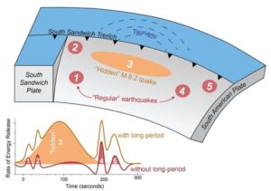
A new study revealed the quake wasn’t a single event, but five, a series of sub-quakes spread out over several minutes. The third sub-quake was a shallower, slower magnitude 8.2 quake that hit just 15 kilometers below the surface. That unusual, “hidden” earthquake was likely the trigger of the worldwide tsunami.

The study was published in the AGU journal Geophysical Research Letters, which publishes short-format, high-impact papers with implications that span the Earth and space sciences.

Because the South Sandwich Islands earthquake was complex, with multiple sub-quakes, its seismic signal was difficult to interpret, according to lead study author Zhe Jia, a seismologist at the California Institute of Technology. The magnitude 8.2 quake was hidden within the tangle of seismic waves, which interfered with each other over the course of the event. The hidden quake’s signal wasn’t clear until Jia filtered the waves using a much longer period, up to 500 seconds. Only then did the 200-second-long quake, which Jia said accounted for over 70% of the energy released during the earthquake, become clear.

“The third event is special because it was huge, and it was silent,” Jia said. “In the data we normally look at [for earthquake monitoring], it was almost invisible.”

Predicting hazards for complex earthquakes can be difficult, as the South Sandwich Islands quake demonstrates. The USGS initially reported the magnitude 7.5 quake and only added the 8.2 event the following day, as the surprise tsunami lapped on shores up to 10,000 kilometers away from its point of origin.

“We need to rethink our way to mitigate earthquake-tsunami hazards. To do that, we need to rapidly and accurately characterize the true size of big earthquakes, as well as their physical processes,” Jia said.

https://strangesounds.org