Hurricane Laura Leaves Trail of CAT-4 Destruction, Looks like 100 Tornadoes struck

Ricky Scaparo – August 27, 2020

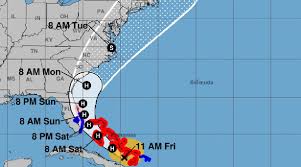
(ETH) – Hurricane Laura is being called one of the strongest hurricanes ever to strike the US is and is moving North and East after pounding the Gulf Coast. Although Laura has reportedly been downgraded to a tropical storm, it has left hurricane damage that stretches for hundreds of miles.

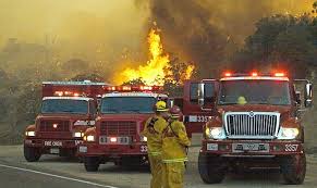
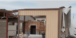
The report from CBN is indicating that streets are flooded, power lines toppled, homes destroyed, and trucks have been tossed like toys. At least three people have been reported to have been killed by falling trees in Louisiana.

Brett Geymann in Moss Bluff, just north of Lake Charles, testified that his family’s OK but “there’s destruction all around”. “It looks like 1,000 tornadoes” came through, he said, with some houses “totally gone.” The report states that destruction extended West across the state line from Louisiana into Texas.

The devastating storm has also produced a large chemical fire that has sent a potentially dangerous cloud over Lake Charles, Louisiana, and has residents being advised to shelter in place. Over half a million people in Texas and Louisiana were forced to evacuate as the storm rapidly strengthened into a catastrophic Category 4 storm in the Gulf of Mexico.

https://www.christianpost.com

Sinabung volcano erupts again just hours after twin M6.8 and M6.9 quakes hit off the coast of Sumatra, Indonesia – M6.6 earthquake the day before in Malaysia

Strange Sounds – August 20, 2020

A pair of powerful earthquakes has rocked the Indonesian coast on August 19, 2020.

The M6.8 and M6.9 quakes shook the island of Sumatra maybe triggering the latest eruption of Sinabung volcano just hours later.

The two quakes struck off Sumatra’s western coast on Wednesday morning, with an estimated depth of 22km (13 miles) and 26km (16 miles) respectively. The first tremor impacted an area some 144km (89 miles) away from Bengkulu, while the second came closer to the city at 130km (80 miles).

There are no reports of injuries as of yet, however local media said the quakes shook the homes of island residents “as if a truck had passed” and did “minor damage,” particularly to buildings with “poor construction.”

Though the jolts were strong and shallow, Indonesia’s Meteorology, Climatology, and Geophysical Agency (BMKG) reported that there was “no tsunami potential” in the quakes’ aftermath.

In addition to being prone to quakes, Indonesia also features some of the most active volcanoes in the Ring – including Krakatoa, whose infamous 1883 eruption became one of the most deadly volcanic blasts in recorded history.

But a few hours after the two big jolts, the Sinabung volcano started erupting again – and not the Krakatoa.

A day before, a M6.6 earthquake hit the Philippines on Tuesday, killing at least one person and damaging roads and buildings.

It was the strongest earthquake in eight months in the Philippines, which, like Indonesia, lies on the “Ring of Fire,” a seismically active belt of volcanoes circling the Pacific Ocean.

https://strangesounds.org

Thousands flee as fast-moving wildfires spread in California

Jocelyne Zablit – August 20, 2020

Thousands of people fled their homes in northern California on Wednesday as hundreds of fast-moving wildfires spread across the region, burning houses and leading to the death of a helicopter pilot.

In Vacaville — a city of about 100,000 people located between the state capital Sacramento and San Francisco — residents were urged to evacuate during the night as the wind-whipped flames swallowed dozens of homes.

Many were awakened by neighbors or firefighters desperately banging on their doors, and rushed out dressed only in their pajamas. Several suffered burns as they ran for their lives.

Evacuation orders or warnings were also issued in other counties — including the wine regions of Sonoma and Napa — where fires sparked by lightning are raging unchecked amid a sweltering heat wave.

Cal Fire officials said the series of fires in that region, dubbed the LNU Lightning Complex, had destroyed 50 homes, burned through nearly 50,000 acres and were zero percent contained by early Wednesday evening.

They added that a helicopter pilot taking part in the firefighting efforts in Fresno County, southeast of San Francisco, had died in a crash as he was attempting to drop water.

In Santa Cruz and San Mateo counties a series of fires called the CZU Lightning Complex forced the shutdown of portions of the iconic coastal Highway 1 as flames came close to the road.

Officials said the region’s rugged terrain and dry vegetation were making it difficult to combat the blaze.

Governor Gavin Newsom, who has declared a state of emergency to facilitate the release of emergency funds, said the wildfires had been caused by thousands of lightning strikes in recent days in the Bay Area.

https://www.terradaily.com

Millions Of Acres Of Crops In The Central U.S. Have Been Destroyed By A Series Of Historic Natural Disasters

– August 12, 2020

While the mainstream media focuses on the upcoming election, COVID-19 and the endless protests going on in our major cities, another great tragedy is unfolding all across the middle of the country.  A nightmarish drought, horrific flooding along the Mississippi River and a giant “derecho” that just hit the farm belt have combined to make this one of the toughest years for farmers ever.  And this comes at a particularly bad time, because the stress that the COVID-19 pandemic has put on food distribution systems has already created periodic shortages of certain items around the nation.  We definitely could have used an uneventful growing season this year, and unfortunately we didn’t get it.

On Monday, an absolutely massive “derecho” roared through the Midwest.  According to USA Today, the storm had winds of up to 112 miles per hour…

The storm had winds of up to 112 mph near Cedar Rapids, Iowa – as powerful as an inland hurricane – as it tore from eastern Nebraska across Iowa and parts of Wisconsin, Indiana and Illinois, including Chicago and its suburbs.

Most hurricanes don’t have winds that high once they finally reach shore, and I have personally never experienced wind speeds of such magnitude.

Needless to say, this very unusual storm caused immense devastation.  According to Iowa Governor Kim Reynolds, approximately 10 million acres of crops were destroyed in Iowa alone…

Early estimates say the derecho flattened at least one-third of Iowa’s crops – about 10 million acres, according to Iowa Gov. Kim Reynolds. In addition, tens of millions of bushels of grain that were stored at co-ops and on farms were damaged or destroyed as bins blew away.

And it rocked Marshalltown, Iowa, where an EF-3 tornado destroyed the town’s business district just two years ago. With winds of 99 mph, Monday’s storm damaged some businesses that had recently recovered, even damaging the scaffolding being used to repair the historic courthouse dome.

I can’t remember a storm ever causing this much damage in the middle of the summer.

If about 10 million acres were flattened just in Iowa, how many more acres did this storm destroy in Nebraska, Wisconsin, Indiana and Illinois?

Sadly, this one storm is going to completely financially ruin some farmers.  For example, Iowa farmer Tim Bardole is facing losses that could potentially exceed one million dollars.

http://theeconomiccollapseblog.com

Hurricane Season Could Get So Bad They Might Run Out Of Names, Scientists Predict

Jordan Lancaster  – August 6, 2020

Scientists are predicting that this year’s hurricane season could get so bad they could run out of traditional names, the Associated Press reported Thursday.

The National Oceanic and Atmospheric Administration (NOAA) is expecting to see double the amount of storm activity this year compared to a normal year, according to the Associated Press. They predicted that there will be anywhere between 19 and 25 storms this year, 7 to 11 of which are expected to become hurricanes. 3 to 6 could become major hurricanes, which are storms with wind speeds reaching at least 111 mph.

Colorado State University also upped their predictions Wednesday, and are now expecting 24 storms, 12 hurricanes, and 5 major hurricanes. An average year has 12 storms, 6 hurricanes, and 3 major hurricanes based on data from 1981 to 2010, according to the report.

“It looks like this season could be one of the more active in the historical record,” NOAA lead forecaster Gerry Bell said, according to the Associated Press. He said that this is the most storms the NOAA has ever predicted. There likely won’t be as many storms as there were in 2005, which experienced a reocrd 28 storms, Bell added, because the conditions that year were more likely to create storms.

University of Miami hurricane researcher Brian McNoldy said that “everything looks ready to be a pretty huge year.” He predicts that there will be more storms than the 21 names that are assigned for every hurricane season, meaning meteorologists will start using the Greek alphabet for names.

There have already been 9 storms this year. Lead Colorado State University forecaster Phil Klotzbach said that “9 storms to this date is crazy,” noting that on average, 12 storms a year come after August 5.

https://dailycaller.com

Florida braces for impact as Hurricane Isaias bears down

Alex Sosnowski – July 31, 2020

Isaias exploded into a Category 1 hurricane, packing 80-mph maximum sustained winds, Thursday night, shortly after pulling away from Hispaniola. The hurricane, which saw winds weaken slightly to 75 mph Friday morning, will churn through the Bahamas through Saturday, and make a run along the Eastern Seaboard of the United States this weekend to early next week.

Hurricane warnings were in effect for the Bahamas on Friday, including hard-hit areas from Dorian in 2019 like the Abaco Islands, although meteorologists expect the impacts to pale in comparison to the monster storm that stalled for 24 hours and caused utter devastation there last year.

“Isaias is expected to be a 1 on the AccuWeather RealImpact™ Scale for Hurricanes in the Bahamas and the coastal southeastern U.S. due to flooding and damaging winds,” AccuWeather Senior Meteorologist Rob Miller said. This scale is a more nuanced method the company introduced in 2019 to assess the potential damage a tropical system could cause.

It has been 25 years since a hurricane tracked through the Bahamas so early in the season, specifically prior to the middle of August. Erin strengthened into a Category 1 hurricane near Rum Cay in the Bahamas and moved through the island chain on Aug. 1-2, 1995, according to Colorado State tropical meteorologist Philip Klotzbach. The storm passed over the Abaco Islands and Grand Bahama, causing generally minor damages, before heading toward Florida.

Isaias’s recent strengthening will help the hurricane forge a track more to the north. And the system could potentially strengthen even more over the very warm waters of the Gulf Stream, especially since Isaias is now expected to avoid the large land mass of Cuba this weekend. While a track up part of the Florida Peninsula is still possible, forecasters have ruled out a track toward the Gulf of Mexico with these developments.

https://www.accuweather.com

Biblical Swarms of Voracious Locusts Jump From Argentina to Brazil, Threatening Winter Crops – Devastating Plague Heading North With Colombia, Guatemala, El Salvador and Belize Already Reporting Insects – Mexico and the U.S. Next?

Strange Sounds – July 20, 2020

Weather conditions may be forming to send a cloud of locusts in northern Argentina over the border to Brazil, threatening winter crops in the giant farming nation.

The locusts are now about 100 kilometers (62 miles) from the Rio Grande do Sul state border.

But wind currents on Wednesday may take the insects into Brazil, Celso Oliveira, a meteorologist at Somar Meteorologia in São Paulo, said by text.

The swarm could harm wheat, canola and barley crops in the western part of the state, as well as native vegetation, he said.

In late June, Brazil’s Agriculture Ministry declared a state of emergency in two southern states to allow officials to take precautions.

The locusts have remained in Argentine territory since then, after arriving from Paraguay in May. A second cloud is in Paraguay, about 300 kilometers from the border, Argentine officials said Thursday.

While the phenomena has always been present in South America, excessive dryness and warmer temperatures this year have seem them thrive. The most recent invasions in Argentina were in 2019 and 2017.

And according to the following videos, the locusts seem to move towards north and start invading countries like Colombia:

https://strangesounds.org

Bang, Bang, Bang! M7.0, M6.0 and M6.1 Earthquakes Hit the Ring of Fire in Papua New Guinea, Chile and India Within 12 Hours

Strange Sounds

3 strong quakes hit within 12 hours this major area in the basin of the Pacific Ocean where many earthquakes and volcanic eruptions occur.

A magnitude 7.0 earthquake struck just off Papua New Guinea in the southwestern Pacific on Friday.

According to the U.S. Geological Survey, the quake occurred at 02:50 a.m. UTC, 114 kilometers north of Popondetta, the capital of Oro Province, at a depth of 79.8 km.

The Pacific Tsunami Warning Center briefly issued a warning for hazardous tsunami waves for Papua New Guinean coastlines located within 300 km of the epicenter.

A strong M6.0 earthquake hit 2 km SSE of Iquique, Chile on July 17, 2020 at 5:40 UTC and at a depth of 73,8 km.

It was reported by many on social media and on the USGS website.

An M6.1 earthquake hit the Andaman and Nicobar Islands on Friday at 2:03 p.m. UTC with an epicenter 250 kms east of Port Blair, the capital of the Andaman and Nicobar Islands in India.

The shallow earthquake struck at a depth of 10 kms.

https://strangesounds.org

In Parched Southwest, Warm Spring Renews Threat of ‘Megadrought’

DNYUZ – July 8, 2020

LOVELAND PASS, Colo. — Here at 12,000 feet on the Continental Divide, only vestiges of the winter snowpack remain, scattered white patches that have yet to melt and feed the upper Colorado River, 50 miles away.

That’s normal for mid-June in the Rockies. What’s unusual this year is the speed at which the snow went. And with it went hopes for a drought-free year in the Southwest.

“We had a really warm spring,” said Graham Sexstone, a hydrologist with the United States Geological Survey. “Everything this year has melted really fast.”

The Southwest has been mired in drought for most of the past two decades. The heat and dryness, made worse by climate change, have been so persistent that some researchers say the region is now caught up in a megadrought, like those that scientists who study past climate say occurred here occasionally over the past 1,200 years and lasted 40 years or longer.

Even a single season of drought is bad news for the Southwest, where agriculture, industry and millions of people rely on the region’s two major rivers, the Colorado and the Rio Grande, and their tributaries for much of their water. Dry conditions also shrivel crops, harm livestock and worsen wildfires.

But droughts, even long ones, eventually end, when the natural variability of climate results in a few “good,” meaning wet, years in a row. So after a relatively cool and wet spring last year followed by a decent snowpack in the fall and winter, there was some optimism that 2020 might be remembered as the year the long Southwestern drought started to fade.

But then came April and May, which were warm and dry, leading to rapid melting and runoff.

Normally, Dr. Sexstone said, measurements of stream flow at gauges in the region would slowly climb to a peak and then drop off gradually as the season progressed.

“This year it seemed like it peaked and then plummeted,” he said.

https://dnyuz.com

Powerful Magnitude 7.4 Earthquake Strikes Off Coast Of New Zealand

ETH – June 18, 2020

(ETH) – A powerful magnitude 7.4 earthquake has struck off the coast of New Zealand with a depth of about 2o miles according to a report.  An alert was released from the UNESCO/IOC Pacific Tsunami warning and mitigation system stated: “Hazardous tsunami waves from this earthquake are possible within 300km of the epicenter.” More information will come as we receive it.

https://endtimeheadlines.org