
Alex Sosnowski – July 31, 2020
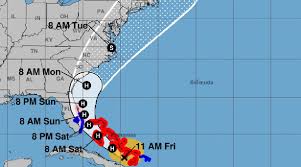
Isaias exploded into a Category 1 hurricane, packing 80-mph maximum sustained winds, Thursday night, shortly after pulling away from Hispaniola. The hurricane, which saw winds weaken slightly to 75 mph Friday morning, will churn through the Bahamas through Saturday, and make a run along the Eastern Seaboard of the United States this weekend to early next week.
Hurricane warnings were in effect for the Bahamas on Friday, including hard-hit areas from Dorian in 2019 like the Abaco Islands, although meteorologists expect the impacts to pale in comparison to the monster storm that stalled for 24 hours and caused utter devastation there last year.
“Isaias is expected to be a 1 on the AccuWeather RealImpact™ Scale for Hurricanes in the Bahamas and the coastal southeastern U.S. due to flooding and damaging winds,” AccuWeather Senior Meteorologist Rob Miller said. This scale is a more nuanced method the company introduced in 2019 to assess the potential damage a tropical system could cause.
It has been 25 years since a hurricane tracked through the Bahamas so early in the season, specifically prior to the middle of August. Erin strengthened into a Category 1 hurricane near Rum Cay in the Bahamas and moved through the island chain on Aug. 1-2, 1995, according to Colorado State tropical meteorologist Philip Klotzbach. The storm passed over the Abaco Islands and Grand Bahama, causing generally minor damages, before heading toward Florida.
Isaias’s recent strengthening will help the hurricane forge a track more to the north. And the system could potentially strengthen even more over the very warm waters of the Gulf Stream, especially since Isaias is now expected to avoid the large land mass of Cuba this weekend. While a track up part of the Florida Peninsula is still possible, forecasters have ruled out a track toward the Gulf of Mexico with these developments.